IMAGES TAKEN NEAR TO
Clareville Grove, LONDON, SW7 5AT
Introduction
This page details the photographs taken nearby to Clareville Grove, SW7 5AT by members of the Geograph project.
The Geograph project started in 2005 with the aim of publishing, organising and preserving representative images for every square kilometre of Great Britain, Ireland and the Isle of Man.

There are currently over 7.5m images from over14,400 individuals and you can help contribute to the project by visiting https://www.geograph.org.uk
Image Map
Images are licensed for reuse under creativecommons.org/licenses/by-sa/2.0
Notes
- Clicking on the map will re-center to the selected point.
- The higher the marker number, the further away the image location is from the centre of the postcode.
Image Listing (304 Images Found)
Images are licensed for reuse under creativecommons.org/licenses/by-sa/2.0
Image
Details
Distance
1
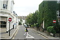
View up Clareville Street from Gloucester Road
Looking north-northeast.
Image: © Robert Lamb
Taken: 14 Jun 2014
0.05 miles
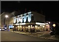
2
The Kensington Hotel, Queen's Gate, South Kensington
Image: © Richard Cooke
Taken: 10 Mar 2018
0.06 miles
3
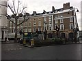
Junction of Queen's Gate with Old Brompton Road, South Kensington
Image: © Richard Cooke
Taken: 11 Mar 2018
0.06 miles
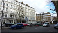
4
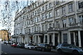
Stanhope Gardens
Grade II listed. https://historicengland.org.uk/listing/the-list/list-entry/1226798
Image: © N Chadwick
Taken: 15 Dec 2019
0.07 miles
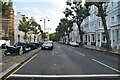
9
View down Gloucester Road
Looking south-southeast.
Image: © Robert Lamb
Taken: 14 Jun 2014
0.08 miles