IMAGES TAKEN NEAR TO
Gloucester Road, LONDON, SW7 4SZ
Introduction
This page details the photographs taken nearby to Gloucester Road, SW7 4SZ by members of the Geograph project.
The Geograph project started in 2005 with the aim of publishing, organising and preserving representative images for every square kilometre of Great Britain, Ireland and the Isle of Man.

There are currently over 7.5m images from over14,400 individuals and you can help contribute to the project by visiting https://www.geograph.org.uk
Image Map (Loading...)


Getting Data...Please wait
Leaflet Map data © OpenStreetMap
Images are licensed for reuse under creativecommons.org/licenses/by-sa/2.0
Notes
- Clicking on the map will re-center to the selected point.
- The higher the marker number, the further away the image location is from the centre of the postcode.
Image Listing (323 Images Found)
Images are licensed for reuse under creativecommons.org/licenses/by-sa/2.0
Image
Details
Distance
2
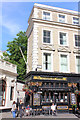
Stanhope Arms
Public House, Gloucester Road.
Image: © Wayland Smith
Taken: 30 Jun 2013
0.02 miles
5
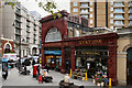
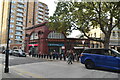
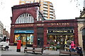
Gloucester Road Underground Station
The above-ground building of the Gloucester Road tube station.
Image: © David Dixon
Taken: 16 May 2012
0.02 miles
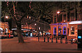
7
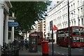
Two 49 buses passing on Gloucester Road
Looking south-southeast.
Image: © Robert Lamb
Taken: 14 Jun 2014
0.03 miles
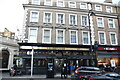
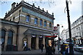
8
Gloucester Road Station
Located on the corner of Gloucester Road and Courtfield Road. Opened in 1868 by the Metropolitan Railway.
Image: © Martin Addison
Taken: 27 Jan 2012
0.03 miles
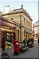
10
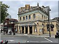
Gloucester Road Underground station, London
Opened in 1868 as the terminus of the Metropolitan Railway's line from Edgware Road, the line was extended to South Kensington 2 months later. It is now part of London Underground's District and Circle lines.
View south west at the forecourt. The nearest building is the 1868 MR station. The red tiled building to the left was opened by the Great Northern Piccadilly & Brompton Railway in 1907 and is now part of the Piccadilly line.
Image: © Nigel Thompson
Taken: 4 Sep 2021
0.03 miles