IMAGES TAKEN NEAR TO
Thurloe Street, LONDON, SW7 2ST
Introduction
This page details the photographs taken nearby to Thurloe Street, SW7 2ST by members of the Geograph project.
The Geograph project started in 2005 with the aim of publishing, organising and preserving representative images for every square kilometre of Great Britain, Ireland and the Isle of Man.

There are currently over 7.5m images from over14,400 individuals and you can help contribute to the project by visiting https://www.geograph.org.uk
Image Map
Images are licensed for reuse under creativecommons.org/licenses/by-sa/2.0
Notes
- Clicking on the map will re-center to the selected point.
- The higher the marker number, the further away the image location is from the centre of the postcode.
Image Listing (1047 Images Found)
Images are licensed for reuse under creativecommons.org/licenses/by-sa/2.0
Image
Details
Distance
7
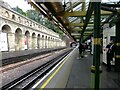
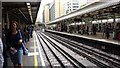
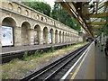
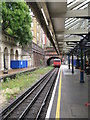
South Kensington Underground station: view eastward from Platform 2
Platform 1 - across the tracks - was last used (so it is said) in 1966. The buildings and canopy on that platform have been taken down, but the site is left looking semi-derelict.
Demolition exposed a long stretch of brickwork arcading - typical of the stations of the old Metropolitan Railway. That railway was originally steam-hauled, leaving the brickwork discoloured by soot until cleaned up at some stage in the late 20th century.
A contribution from Dr Neil Clifton shows Platform 1 as it was in 1979 - partly demolished https://www.geograph.org.uk/photo/523586 Lewis Clark's view from street-level shows that extensive dereliction remained as late as 2018: https://www.geograph.org.uk/photo/5979856
Image: © Stefan Czapski
Taken: 21 Sep 2021
0.02 miles
8
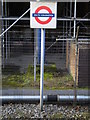
Tube sign, South Kensington Underground Station
Image: © Robin Sones
Taken: 6 Apr 2010
0.02 miles
10
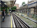
London : Kensington - South Kensington Tube Station
The station is in London fare zone 1. On the District and Circle lines, the station is between Gloucester Road and Sloane Square, and on the Piccadilly line, it is between Gloucester Road and Knightsbridge.
Image: © Lewis Clarke
Taken: 15 Aug 2010
0.02 miles