
IMAGES TAKEN NEAR TO
Prince's Gate, LONDON, SW7 1LW
Introduction
This page details the photographs taken nearby to Prince's Gate, SW7 1LW by members of the Geograph project.
The Geograph project started in 2005 with the aim of publishing, organising and preserving representative images for every square kilometre of Great Britain, Ireland and the Isle of Man.

There are currently over 7.5m images from over14,400 individuals and you can help contribute to the project by visiting https://www.geograph.org.uk
Image Map
Images are licensed for reuse under creativecommons.org/licenses/by-sa/2.0
Notes
- Clicking on the map will re-center to the selected point.
- The higher the marker number, the further away the image location is from the centre of the postcode.
Image Listing (530 Images Found)
Images are licensed for reuse under creativecommons.org/licenses/by-sa/2.0
Image
Details
Distance
1
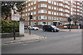
Junction of Ennismore Gardens and Kensington Road
The white stone wall pier on the corner has an OS benchmark Image near its base. The view is from Prince's Gate.
Image: © Roger Templeman
Taken: 28 Feb 2013
0.04 miles
2
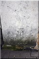
Benchmark on wall pier at north end of Ennismore Gardens
Ordnance Survey cut mark benchmark described on the Bench Mark Database at http://www.bench-marks.org.uk/bm47378
Image: © Roger Templeman
Taken: 28 Feb 2013
0.04 miles
3
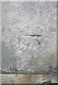
Ordnance Survey Cut Mark
This OS cut mark can be found on the post at the junction of Kensington Road & Ennismore Gardens. It marks a point 19.844m above mean sea level.
Image: © Adrian Dust
Taken: 30 Sep 2019
0.04 miles
4
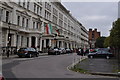
London : Kensington - Prince's Gate
The Iranian embassy can be seen here. Well known for the siege of course. It was the only one with security along this road.
Image: © Lewis Clarke
Taken: 13 Oct 2010
0.05 miles
5
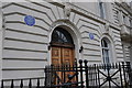
London : Kensington - The Royal College of General Practitioners
Junius S Morgan and John Pierpont Morgan the international bankers lived here. President John Fitzgerald Kennedy also lived here.
Image: © Lewis Clarke
Taken: 13 Oct 2010
0.05 miles
6
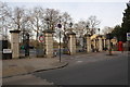
Prince of Wales Gate entrance to Hyde Park
In 1849 the Ordnance Survey cut a benchmark, http://www.bench-marks.org.uk/bm36513 on the 4th (from the left) gate pillar. The mark is shown on maps up to 1906, but not on maps from 1916. There is no mark there now which suggests the pillars may have been replaced before 1916?
Image: © Roger Templeman
Taken: 28 Feb 2013
0.06 miles
7
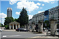
Prince of Wales Gate, Hyde Park
A pair of lodges by Decimus Burton in 1847 and 1851. Grade II listed.
Further along Knightsbridge is Image
Image: © Stephen Richards
Taken: 7 Jun 2015
0.06 miles
8
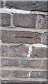
Ordnance Survey Cut Mark
This OS cut mark can be found on the wall north side of Kensington Road. It marks a point 20.405m above mean sea level.
Image: © Adrian Dust
Taken: 30 Sep 2019
0.06 miles
9

View of the Hyde Park Barracks tower from the crossing on Kensington Road
Looking east-southeast.
Image: © Robert Lamb
Taken: 21 Mar 2015
0.07 miles
10
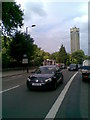
Kensington Road
Showing a Volkswagen Golf MkVI. The tower in the background is Kensington Barracks, which has a lift big enough for a horse to be ridden into the mess on the top floor.
Image: © Burgess Von Thunen
Taken: 6 Jun 2010
0.07 miles