IMAGES TAKEN NEAR TO
Montpelier Square, LONDON, SW7 1JR
Introduction
This page details the photographs taken nearby to Montpelier Square, SW7 1JR by members of the Geograph project.
The Geograph project started in 2005 with the aim of publishing, organising and preserving representative images for every square kilometre of Great Britain, Ireland and the Isle of Man.

There are currently over 7.5m images from over14,400 individuals and you can help contribute to the project by visiting https://www.geograph.org.uk
Image Map
Images are licensed for reuse under creativecommons.org/licenses/by-sa/2.0
Notes
- Clicking on the map will re-center to the selected point.
- The higher the marker number, the further away the image location is from the centre of the postcode.
Image Listing (498 Images Found)
Images are licensed for reuse under creativecommons.org/licenses/by-sa/2.0
Image
Details
Distance
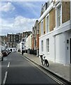
1
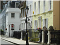
Montpelier Place, Knightsbridge
The quiet, and very exclusive, back streets of Knightsbridge contain some of the most expensive properties in London.
Image: © Stephen McKay
Taken: 29 Jun 2007
0.03 miles
2
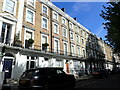
The north side of Montpelier Square
This is the very exclusive area between Brompton Road and Hyde Park. As with all the squares in this area, the gardens in the centre of the square are only for the residents.
Image: © Marathon
Taken: 11 Sep 2023
0.03 miles
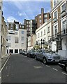
3
The south side of Montpelier Square
This is the very exclusive area between Brompton Road and Hyde Park. As with all the squares in this area, the gardens in the centre of the square are only for the residents.
Image: © Marathon
Taken: 11 Sep 2023
0.03 miles
5
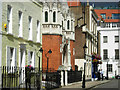
Montpelier Place, Knightsbridge
The ornate church is the Deutsche Evangelische Christuskirche; construction started in 1904, in a location that would not in those days have been regarded as especially exclusive, to provide a permanent home for London's small German congregation. The Tea Clipper pub is further along the street.
Image: © Stephen McKay
Taken: 29 Jun 2007
0.04 miles
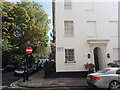
6
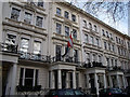
Austrian Institute, Rutland Gate
The Austrian flag - and that of the European Union - fly outside no. 28; a sign above advertises the Austrian Institute. The houses on this side of the square (28-32) are listed grade 2 (list entry number 1235363).
Image: © Stephen Craven
Taken: 22 Feb 2014
0.04 miles
7
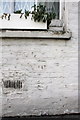
Benchmark on #47 Montpelier Walk
Ordnance Survey cut mark benchmark described on the Bench Mark Database at http://www.bench-marks.org.uk/bm47504
Image: © Roger Templeman
Taken: 28 Feb 2013
0.05 miles
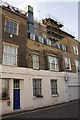
8
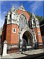
German Christ Church, Montpelier Place
The Deutsche Evangelische Christuskirche has been described as the most significant German church in London. The church was built between 1904 and 1905 and was dedicated on 27th November 1904. For more about the church see https://en.wikipedia.org/wiki/Deutsche_Evangelische_Christuskirche
Image: © Marathon
Taken: 11 Sep 2023
0.05 miles
10
Housing on Montpelier Walk
There is an OS benchmark Image under the ground floor window second to the right of the blue door.
Image: © Roger Templeman
Taken: 28 Feb 2013
0.05 miles