IMAGES TAKEN NEAR TO
Montpelier Walk, LONDON, SW7 1JG
Introduction
This page details the photographs taken nearby to Montpelier Walk, SW7 1JG by members of the Geograph project.
The Geograph project started in 2005 with the aim of publishing, organising and preserving representative images for every square kilometre of Great Britain, Ireland and the Isle of Man.

There are currently over 7.5m images from over14,400 individuals and you can help contribute to the project by visiting https://www.geograph.org.uk
Image Map
Images are licensed for reuse under creativecommons.org/licenses/by-sa/2.0
Notes
- Clicking on the map will re-center to the selected point.
- The higher the marker number, the further away the image location is from the centre of the postcode.
Image Listing (571 Images Found)
Images are licensed for reuse under creativecommons.org/licenses/by-sa/2.0
Image
Details
Distance
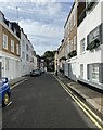
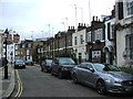
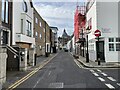
7
Fairholt Street, Knightsbridge
This is the very exclusive area between Brompton Road and Hyde Park. The dome of Brompton Oratory can be seen in the distance.
Image: © Marathon
Taken: 11 Sep 2023
0.03 miles
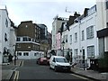
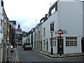
9
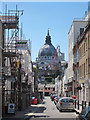
Cheval Place
The dome roof of Brompton Oratory seen ahead.
Image: © Oast House Archive
Taken: 26 Jun 2011
0.03 miles