IMAGES TAKEN NEAR TO
Shorrolds Road, LONDON, SW6 7TU
Introduction
This page details the photographs taken nearby to Shorrolds Road, SW6 7TU by members of the Geograph project.
The Geograph project started in 2005 with the aim of publishing, organising and preserving representative images for every square kilometre of Great Britain, Ireland and the Isle of Man.

There are currently over 7.5m images from over14,400 individuals and you can help contribute to the project by visiting https://www.geograph.org.uk
Image Map
Images are licensed for reuse under creativecommons.org/licenses/by-sa/2.0
Notes
- Clicking on the map will re-center to the selected point.
- The higher the marker number, the further away the image location is from the centre of the postcode.
Image Listing (93 Images Found)
Images are licensed for reuse under creativecommons.org/licenses/by-sa/2.0
Image
Details
Distance
1
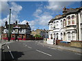
Fulham: A3219 Dawes Road and sewer vent pipe
Viewed looking in the direction of Hammersmith with Image to the left.
Image: © Nigel Cox
Taken: 22 Jun 2008
0.04 miles
2
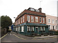
Fulham Mitre public house, SW6
Located at 81 Dawes Road (to the right) at the junction with Bishop's Road (to the left), the pub has its website here http://www.fulhammitre.com/html/index.php According to the website it has been a winner of the Morning Advertiser's Best Leased Pub in England and Wales award.
Image: © Nigel Cox
Taken: 22 Jun 2008
0.04 miles
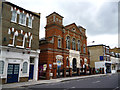
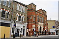
7
Fulham Baptist Church
On Dawes Road, Fulham
Image: © Neil Theasby
Taken: 15 Jul 2022
0.08 miles
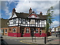
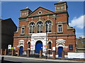
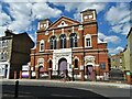
9
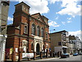
Fulham Baptist Church
Located at 118 Dawes Road, SW6, the building appears as a Chapel on the 1896 Ordnance Survey mapping.
Image: © Nigel Cox
Taken: 22 Jun 2008
0.12 miles