IMAGES TAKEN NEAR TO
Letterstone Road, LONDON, SW6 7BS
Introduction
This page details the photographs taken nearby to Letterstone Road, SW6 7BS by members of the Geograph project.
The Geograph project started in 2005 with the aim of publishing, organising and preserving representative images for every square kilometre of Great Britain, Ireland and the Isle of Man.

There are currently over 7.5m images from over14,400 individuals and you can help contribute to the project by visiting https://www.geograph.org.uk
Image Map
Images are licensed for reuse under creativecommons.org/licenses/by-sa/2.0
Notes
- Clicking on the map will re-center to the selected point.
- The higher the marker number, the further away the image location is from the centre of the postcode.
Image Listing (96 Images Found)
Images are licensed for reuse under creativecommons.org/licenses/by-sa/2.0
Image
Details
Distance
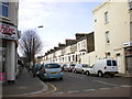
1
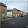
Corner of Orbain Road and Varna Road
Terracing housing densely filling the area.
Image: © James Emmans
Taken: 22 Nov 2022
0.03 miles
2
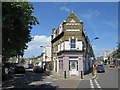
Tesco Express, Fulham
Small supermarket on the junction of Estcourt Road and Dawes Road (on the right).
Image: © David Anstiss
Taken: 14 Apr 2013
0.06 miles
3
Varna Road & Filmer Road junction
Varna Road left.
Image: © Oast House Archive
Taken: 4 Jun 2015
0.07 miles
5
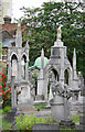
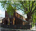
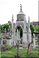
St Thomas of Canterbury, Rylston Road, Fulham - Churchyard
Image: © John Salmon
Taken: 17 May 2011
0.08 miles
6

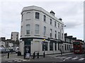
Beer garden of "The Captain Cook" pub, Fulham
On Dawes Road
Image: © Neil Theasby
Taken: 15 Jul 2022
0.08 miles
7
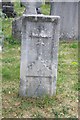
St Thomas of Canterbury, Rylston Road, Fulham - Churchyard
Image: © John Salmon
Taken: 17 May 2011
0.08 miles
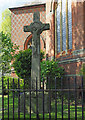
9
St Thomas of Canterbury, Rylston Road, Fulham - Churchyard
Image: © John Salmon
Taken: 17 May 2011
0.09 miles