IMAGES TAKEN NEAR TO
Stevenage Road, LONDON, SW6 6QS
Introduction
This page details the photographs taken nearby to Stevenage Road, SW6 6QS by members of the Geograph project.
The Geograph project started in 2005 with the aim of publishing, organising and preserving representative images for every square kilometre of Great Britain, Ireland and the Isle of Man.

There are currently over 7.5m images from over14,400 individuals and you can help contribute to the project by visiting https://www.geograph.org.uk
Image Map (Loading...)


Getting Data...Please wait
Leaflet Map data © OpenStreetMap
Images are licensed for reuse under creativecommons.org/licenses/by-sa/2.0
Notes
- Clicking on the map will re-center to the selected point.
- The higher the marker number, the further away the image location is from the centre of the postcode.
Image Listing (167 Images Found)
Images are licensed for reuse under creativecommons.org/licenses/by-sa/2.0
Image
Details
Distance
1
View of Alder Lodge, Eternit Walk, Fulham and the Fulham FC floodlights from Peacock Tower in the London Wetlands Centre
Looking south-southeast.
Image: © Robert Lamb
Taken: 19 Apr 2015
0.03 miles
2
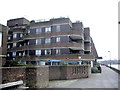
Cedar Lodge, Stevenage Road, Fulham
Image: © Alexander P Kapp
Taken: 23 Dec 2007
0.03 miles
3
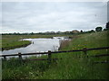
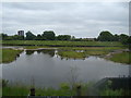
View of houses on Wyatt Drive from the London Wetland Centre #4
Looking north-northeast.
Image: © Robert Lamb
Taken: 9 Jun 2013
0.04 miles
4
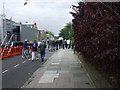
Stevenage Road, SW6
People walking towards Fulham FC for the televised game with Arsenal, the trucks on the left are all the Setanta vehicles with the generators and other equipment to show the game live.
Image: © Phillip Perry
Taken: 23 Aug 2008
0.05 miles
5
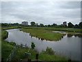
View of Clifton and Golding Houses, Aspenlea Road, houses on Wyatt Drive and Chelsea Power Station from Peacock Tower
Looking east.
Image: © Robert Lamb
Taken: 9 Jun 2013
0.06 miles
6
View of Charing Cross Hospital and Clifton and Golding Houses in Fulham from Peacock Tower in the London Wetlands Centre
Looking north-northeast.
Image: © Robert Lamb
Taken: 9 Jun 2013
0.06 miles
7
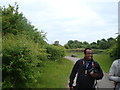
View of Clifton and Golding Houses from the path leading to Peacock Tower
Looking north-northeast.
Image: © Robert Lamb
Taken: 9 Jun 2013
0.07 miles
8
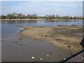
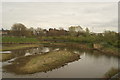
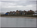
Spit in the Thames
This is on the site of Blakes Wharf, where goods were imported and exported. There is now housing (Millshott Close). On the far bank is the London Wetland Centre.
Image: © Derek Harper
Taken: 15 Apr 2010
0.07 miles
10
Riverside Gardens, Stevenage Road, Fulham
Taken from South Bank Sailing Club.
Image: © Alexander P Kapp
Taken: 6 Feb 2011
0.10 miles