IMAGES TAKEN NEAR TO
Whittingstall Road, LONDON, SW6 4ED
Introduction
This page details the photographs taken nearby to Whittingstall Road, SW6 4ED by members of the Geograph project.
The Geograph project started in 2005 with the aim of publishing, organising and preserving representative images for every square kilometre of Great Britain, Ireland and the Isle of Man.

There are currently over 7.5m images from over14,400 individuals and you can help contribute to the project by visiting https://www.geograph.org.uk
Image Map
Images are licensed for reuse under creativecommons.org/licenses/by-sa/2.0
Notes
- Clicking on the map will re-center to the selected point.
- The higher the marker number, the further away the image location is from the centre of the postcode.
Image Listing (171 Images Found)
Images are licensed for reuse under creativecommons.org/licenses/by-sa/2.0
Image
Details
Distance
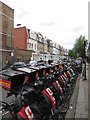
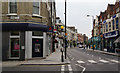
4

London : Hammersmith And Fulham - Fulham Road
A road with shops including Little Heroes, Local Heroes Coffee and The French Barre in view.
Image: © Lewis Clarke
Taken: 11 Jun 2016
0.05 miles
5

London : Hammersmith And Fulham - Fulham Road
Heading along Fulham Road.
Image: © Lewis Clarke
Taken: 11 Jun 2016
0.05 miles
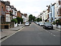
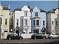
6
Fulham Road
A town centre section on the A304.
Image: © Bill Boaden
Taken: 29 Jul 2011
0.06 miles
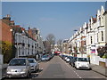
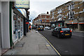
8

London : Hammersmith And Fulham - Fulham Road
Looking along Fulham Road.
Image: © Lewis Clarke
Taken: 11 Jun 2016
0.07 miles
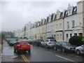
9
London : Hammersmith And Fulham - Fulham Road
Looking along Fulham Road.
Image: © Lewis Clarke
Taken: 11 Jun 2016
0.07 miles