IMAGES TAKEN NEAR TO
St. Maur Road, LONDON, SW6 4DP
Introduction
This page details the photographs taken nearby to St. Maur Road, SW6 4DP by members of the Geograph project.
The Geograph project started in 2005 with the aim of publishing, organising and preserving representative images for every square kilometre of Great Britain, Ireland and the Isle of Man.

There are currently over 7.5m images from over14,400 individuals and you can help contribute to the project by visiting https://www.geograph.org.uk
Image Map
Images are licensed for reuse under creativecommons.org/licenses/by-sa/2.0
Notes
- Clicking on the map will re-center to the selected point.
- The higher the marker number, the further away the image location is from the centre of the postcode.
Image Listing (177 Images Found)
Images are licensed for reuse under creativecommons.org/licenses/by-sa/2.0
Image
Details
Distance
1
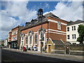
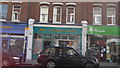
Fulham Library
The library is located at 598 Fulham Road, SW6. Reviewing the old large scale Ordnance Survey maps of the area it is evident that the building was not present in 1898 but it was in 1920. The building is substantially longer than the frontage seen here.
Image: © Nigel Cox
Taken: 22 Jun 2008
0.05 miles
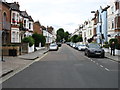
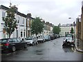
7
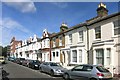
Epple Road, Fulham
An area of smartly restored terrace houses.
Image: © Des Blenkinsopp
Taken: 23 Sep 2015
0.06 miles