IMAGES TAKEN NEAR TO
Ranelagh Gardens, LONDON, SW6 3PA
Introduction
This page details the photographs taken nearby to Ranelagh Gardens, SW6 3PA by members of the Geograph project.
The Geograph project started in 2005 with the aim of publishing, organising and preserving representative images for every square kilometre of Great Britain, Ireland and the Isle of Man.

There are currently over 7.5m images from over14,400 individuals and you can help contribute to the project by visiting https://www.geograph.org.uk
Image Map
Images are licensed for reuse under creativecommons.org/licenses/by-sa/2.0
Notes
- Clicking on the map will re-center to the selected point.
- The higher the marker number, the further away the image location is from the centre of the postcode.
Image Listing (543 Images Found)
Images are licensed for reuse under creativecommons.org/licenses/by-sa/2.0
Image
Details
Distance
1
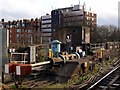
Hydraulic buffers and war-time pill box at Putney Underground Station in Fulham
Image: © tristan forward
Taken: 7 Feb 2011
0.01 miles
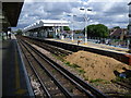
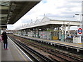
2
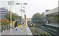
Putney Bridge Station, looking south towards the Bridge
View southward, towards East Putney and Wimbledon, from Platforms 1/2 of which No. 2 is a dead-end bay: London Underground District Line, Earls Court etc. - Wimbledon. (See Image] for the view the other way).
Image: © Ben Brooksbank
Taken: 3 Nov 2006
0.01 miles
4
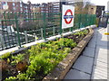
Flower bed at Putney Bridge station
An effort has been made to brighten the down District line platform at Putney Bridge station.
Image: © Marathon
Taken: 5 Apr 2019
0.01 miles
7
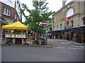
Putney Bridge Station Approach
Looking towards the station and market from the corner of Ranelagh Gardens
Image: © David Howard
Taken: 18 May 2008
0.01 miles
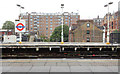
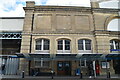
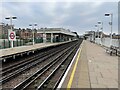
8
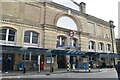
Putney Bridge station
The station was opened on 1st March 1880 as Putney Bridge & Fulham when the Metropolitan District Railway extended its line south from West Brompton. The station served as the terminus of the line until 1889 when the MDR built Fulham Railway Bridge across the River Thames and extended the line south to the London and South Western Railway's newly-built East Putney station where it connected to the L&SWR's new line to Wimbledon. Services from the station to Wimbledon began on 3rd June 1889. On 1st January 1902, the station was renamed Putney Bridge & Hurlingham referring to the nearby Hurlingham Park. It received its current name in 1932 and is now on the District Line. Almost the whole way from Fulham Broadway to East Putney is on viaduct.
Image: © Marathon
Taken: 8 Jun 2011
0.01 miles
10
Putney Bridge Underground station, London
Opened in 1880 as "Putney Bridge & Fulham" by the District Railway, on what is now London Underground's District Line from Wimbledon to Earls Court. The name was changed in 1902 to "Putney Bridge & Hurlingham", and in 1938 to plain "Putney Bridge".
View south towards East Putney and Wimbledon. Like 55% of the London Underground network, this part is actually overground.
Image: © Nigel Thompson
Taken: 4 Sep 2021
0.01 miles