IMAGES TAKEN NEAR TO
Dymock Street, LONDON, SW6 3ET
Introduction
This page details the photographs taken nearby to Dymock Street, SW6 3ET by members of the Geograph project.
The Geograph project started in 2005 with the aim of publishing, organising and preserving representative images for every square kilometre of Great Britain, Ireland and the Isle of Man.

There are currently over 7.5m images from over14,400 individuals and you can help contribute to the project by visiting https://www.geograph.org.uk
Image Map (Loading...)


Getting Data...Please wait
Leaflet Map data © OpenStreetMap
Images are licensed for reuse under creativecommons.org/licenses/by-sa/2.0
Notes
- Clicking on the map will re-center to the selected point.
- The higher the marker number, the further away the image location is from the centre of the postcode.
Image Listing (148 Images Found)
Images are licensed for reuse under creativecommons.org/licenses/by-sa/2.0
Image
Details
Distance
1
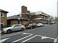
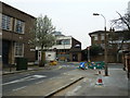
Putney Bridge to Parsons Green and back via Hurlingham (158)
Approaching the junction of Peterborough Road and Philpot Square.
Image: © Basher Eyre
Taken: 26 Mar 2011
0.04 miles
2
Putney Bridge to Parsons Green and back via Hurlingham (160)
Looking from the junction of Carnwath and Peterborough Roads.
Image: © Basher Eyre
Taken: 26 Mar 2011
0.05 miles
3
Putney Bridge to Parsons Green and back via Hurlingham (153)
Looking from South Park towards Thomas's Fulham.
Image: © Basher Eyre
Taken: 26 Mar 2011
0.05 miles
4
Putney Bridge to Parsons Green and back via Hurlingham (155)
Hugon Road
Image: © Basher Eyre
Taken: 26 Mar 2011
0.06 miles
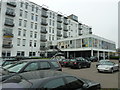
5
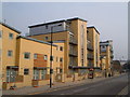
Apartments on Townmead Road, Fulham
The stretch of the road leading away from Wandsworth Bridge Road, opposite the industrial premises backing onto the Thames wharves.
Image: © Derek Harper
Taken: 14 Oct 2006
0.07 miles
6
Putney Bridge to Parsons Green and back via Hurlingham (161)
Junction of Peterborough Road and Carnwath Road
Image: © Basher Eyre
Taken: 26 Mar 2011
0.07 miles
7
Putney Bridge to Parsons Green and back via Hurlingham (156)
Approaching the junction of Hugon and Peterborough Road.
Image: © Basher Eyre
Taken: 26 Mar 2011
0.08 miles
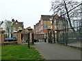
8

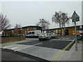
Hurlingham: Elizabethan School
This splendid mock-Jacobean building was completed in 1855, the work of Horace Francis, originally being a ragged school. It has since had a variety of uses, the last use known to me being as a Youth Club. At present it appears to be disused - the entrances are secured and notices carrying dire warnings about guard dogs are posted everywhere. The building is Grade II listed. It would clearly be wasted as a care home, and is not suitable anyway for such a use. It could possibly find a use as an academic library, or a music centre.
Image: © Dr Neil Clifton
Taken: 17 May 2013
0.08 miles
9
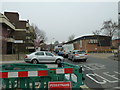
Putney Bridge to Parsons Green and back via Hurlingham (159)
Junction of Carnwath and Peterborough Roads.
Image: © Basher Eyre
Taken: 26 Mar 2011
0.08 miles
10
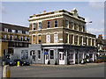
The Hurlingham
The feature at the top of the building, unfortunately undated, shows that this was originally the Wandsworth Bridge Tavern.
Image: © Robin Webster
Taken: 14 Apr 2012
0.08 miles