IMAGES TAKEN NEAR TO
Watermeadow Lane, LONDON, SW6 2RW
Introduction
This page details the photographs taken nearby to Watermeadow Lane, SW6 2RW by members of the Geograph project.
The Geograph project started in 2005 with the aim of publishing, organising and preserving representative images for every square kilometre of Great Britain, Ireland and the Isle of Man.

There are currently over 7.5m images from over14,400 individuals and you can help contribute to the project by visiting https://www.geograph.org.uk
Image Map (Loading...)


Getting Data...Please wait
Leaflet Map data © OpenStreetMap
Images are licensed for reuse under creativecommons.org/licenses/by-sa/2.0
Notes
- Clicking on the map will re-center to the selected point.
- The higher the marker number, the further away the image location is from the centre of the postcode.
Image Listing (154 Images Found)
Images are licensed for reuse under creativecommons.org/licenses/by-sa/2.0
Image
Details
Distance
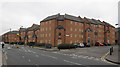
4
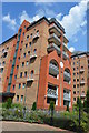
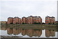
Waterman's Quay, Sands End
A large apartment block built in the late 1990s with three wings jutting out towards the Thames, and backing onto William Morris Way.
Image: © Derek Harper
Taken: 14 Oct 2006
0.05 miles
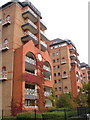
5
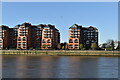
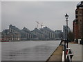
Riverside apartment blocks, Battersea Reach
Image: © N Chadwick
Taken: 25 Aug 2010
0.05 miles
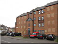
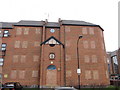
8
New development
On the north side of Battersea Reach, opposite Plantation Wharf
Image: © Alexander P Kapp
Taken: 26 Dec 2007
0.06 miles
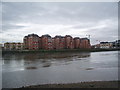
10
View to Juniper Drive apartments
Image: © Oast House Archive
Taken: 19 Mar 2015
0.06 miles