IMAGES TAKEN NEAR TO
Tynemouth Street, LONDON, SW6 2QS
Introduction
This page details the photographs taken nearby to Tynemouth Street, SW6 2QS by members of the Geograph project.
The Geograph project started in 2005 with the aim of publishing, organising and preserving representative images for every square kilometre of Great Britain, Ireland and the Isle of Man.

There are currently over 7.5m images from over14,400 individuals and you can help contribute to the project by visiting https://www.geograph.org.uk
Image Map (Loading...)


Getting Data...Please wait
Leaflet Map data © OpenStreetMap
Images are licensed for reuse under creativecommons.org/licenses/by-sa/2.0
Notes
- Clicking on the map will re-center to the selected point.
- The higher the marker number, the further away the image location is from the centre of the postcode.
Image Listing (126 Images Found)
Images are licensed for reuse under creativecommons.org/licenses/by-sa/2.0
Image
Details
Distance
2
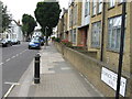
Fulham: West London Coroner's Court
This functional building in Bagley's Lane, SW6, is the West London Coroner's Court. As well as dealing with mortalities in West London, inquests into the deaths of UK citizens overseas are held here, for example those that occurred during the Asian Tsunami of 26 December 2004.
The 1920 and 1938 Ordnance Survey 1:10,560 scale maps both show this road as Brill Street, with Bagley's Lane only commencing further to the north-west.
Image: © Nigel Cox
Taken: 22 Jun 2008
0.06 miles
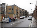
4
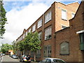
Fulham: The Gallery, SW6
This site, bounded by Townmead Road, Elbe Street, Elswick Street, and Brill Street (now Bagley's Lane) was originally a primary school, and certainly existed as such by 1916 for it is shown on the Ordnance Survey 1:2,500 scale map edition of that year. However with changing demographics it became surplus to requirements and was sold off in the 1970s. By 1975 it had been acquired by The Chelsea College of Art and Design and was used as a studio annexe. In 2005 the College merged all their campus sites into one at the Millbank, and disposed of this one. The site has now been acquired for residential development as 'the gallery | sw6' and the developers' website is here http://www.thegallerysw6.com/index.htm I only hope there are enough primary school places for all the new residents...
Image: © Nigel Cox
Taken: 22 Jun 2008
0.06 miles
7
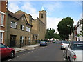
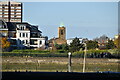
Fulham: Catholic Church of Our Lady of Perpetual Help
This is the view down Tynemouth Street towards the Church, although the main entrance is past the tower and around to the left in Stephendale Road. The Church was built in 1922 to the designs of the catholic Priest Fr Benedict Williamson, and was funded by a lady in memory of her son who was killed in 1914 during the First World War. Some of the internal architecture is of an Egyptian style reflecting the contemporary interest in all things Egyptian around that time, when the Tomb of Tutankhamun had just been discovered by Howard Carter.
Image: © Nigel Cox
Taken: 22 Jun 2008
0.07 miles
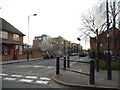
9

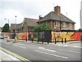
The entrance to Bagleys Lane depot
The council maintenance depot for their vehicles, the coroners court is on the right.
Image: © David Howard
Taken: 16 Mar 2014
0.07 miles
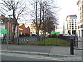
10

Bagleys Lane depot, Sands End
The council maintenance depot
Image: © David Howard
Taken: 16 Mar 2014
0.07 miles