IMAGES TAKEN NEAR TO
Parkland Walk, SW6 2QG
Introduction
This page details the photographs taken nearby to Parkland Walk, SW6 2QG by members of the Geograph project.
The Geograph project started in 2005 with the aim of publishing, organising and preserving representative images for every square kilometre of Great Britain, Ireland and the Isle of Man.

There are currently over 7.5m images from over14,400 individuals and you can help contribute to the project by visiting https://www.geograph.org.uk
Image Map
Images are licensed for reuse under creativecommons.org/licenses/by-sa/2.0
Notes
- Clicking on the map will re-center to the selected point.
- The higher the marker number, the further away the image location is from the centre of the postcode.
Image Listing (202 Images Found)
Images are licensed for reuse under creativecommons.org/licenses/by-sa/2.0
Image
Details
Distance
1
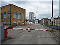
Former gas works, Sands End Lane
The old gas works site is due to become one of London's hottest hotbeds of activity. It should result in around 2000 homes, but will take almost twenty years. Everything will be swept away apart from a few listed structures: a gas-holder (apparently the only one of its type anywhere in the world), the two-storey white building (former offices), the red brick building to its right (former laboratory), and a war memorial.
The tower in the background belongs to yet another scheme named by putting a word after Chelsea, in this case "Creek".
Image: © Stephen Richards
Taken: 23 Mar 2019
0.06 miles
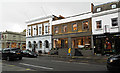
2
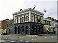
The Imperial Arms
According to their website, the Imperial Arms is a traditional London Victorian pub showcasing the best in contemporary photography.
Image: © Robin Webster
Taken: 14 Apr 2012
0.07 miles
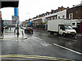
3
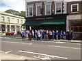
Chelsea fans outside "The Imperial Arms"
On Kings Road before the first match of the 2013-14 season versus Hull City A.F.C.
Image: © Neil Theasby
Taken: 18 Aug 2013
0.07 miles
4
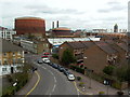
Harwood Terrace, London SW6
View over Harwood Terrace SW6 towards the gasometers to the east with the Lots Road power station stacks [decommissioned] in the background. The tower to the rear right of the frame is the Belvedere Tower in Chelsea Harbour
Image: © Paul Leonard
Taken: 11 Mar 2003
0.07 miles
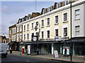
6
King's Road, London SW6
Showing position of Postbox No. SW6 10.
See Image] for postbox.
Image: © JThomas
Taken: 27 May 2022
0.07 miles
7
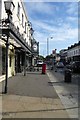
King's Road
A torrential downpour which lasted for around thirty minutes.
Image: © Thomas Nugent
Taken: 8 Oct 2014
0.07 miles
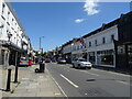
8
King's Road
Shops at the corner of Michael Road.
Image: © Thomas Nugent
Taken: 8 Oct 2014
0.07 miles
9
600 - 606 (evens) King's Road
With an elegant covered frontage, and clock. The lamp above the clock has '600' on the glass.
Image: © Robin Webster
Taken: 14 Apr 2012
0.07 miles
10
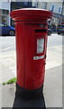
George V postbox on King's Road
Postbox No. SW6 10.
See Image] for context.
Image: © JThomas
Taken: 27 May 2022
0.07 miles