IMAGES TAKEN NEAR TO
Bagleys Lane, LONDON, SW6 2BW
Introduction
This page details the photographs taken nearby to Bagleys Lane, SW6 2BW by members of the Geograph project.
The Geograph project started in 2005 with the aim of publishing, organising and preserving representative images for every square kilometre of Great Britain, Ireland and the Isle of Man.

There are currently over 7.5m images from over14,400 individuals and you can help contribute to the project by visiting https://www.geograph.org.uk
Image Map
Images are licensed for reuse under creativecommons.org/licenses/by-sa/2.0
Notes
- Clicking on the map will re-center to the selected point.
- The higher the marker number, the further away the image location is from the centre of the postcode.
Image Listing (121 Images Found)
Images are licensed for reuse under creativecommons.org/licenses/by-sa/2.0
Image
Details
Distance
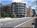
1
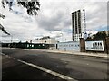
Chelsea Creek development in progress
Building luxury apartments on a dockside location by the Berkeley Group.
Image: © James Emmans
Taken: 28 May 2022
0.04 miles
4

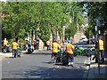
The entrance to Bagleys Lane depot
The council maintenance depot for their vehicles, the coroners court is on the right.
Image: © David Howard
Taken: 16 Mar 2014
0.06 miles
5

Bagleys Lane depot, Sands End
The council maintenance depot
Image: © David Howard
Taken: 16 Mar 2014
0.06 miles
7
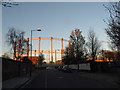
Gas Holder by Imperial Road
From Fulmead Street
Image: © David Howard
Taken: 16 Mar 2014
0.06 miles
8
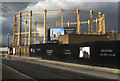
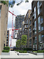
Gas holder, Chelsea Creek
Grade II listed structure, thought to be the oldest gas holder in the world. 1830
Image: © Jim Osley
Taken: 14 Feb 2013
0.07 miles
10
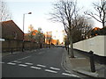
Fulmead Street at the junction of Bagleys Lane
Image: © David Howard
Taken: 16 Mar 2014
0.08 miles