IMAGES TAKEN NEAR TO
Telephone Place, LONDON, SW6 1TH
Introduction
This page details the photographs taken nearby to Telephone Place, SW6 1TH by members of the Geograph project.
The Geograph project started in 2005 with the aim of publishing, organising and preserving representative images for every square kilometre of Great Britain, Ireland and the Isle of Man.

There are currently over 7.5m images from over14,400 individuals and you can help contribute to the project by visiting https://www.geograph.org.uk
Image Map
Images are licensed for reuse under creativecommons.org/licenses/by-sa/2.0
Notes
- Clicking on the map will re-center to the selected point.
- The higher the marker number, the further away the image location is from the centre of the postcode.
Image Listing (146 Images Found)
Images are licensed for reuse under creativecommons.org/licenses/by-sa/2.0
Image
Details
Distance
2
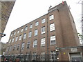
Fulham Telephone Exchange (1)
Situated in Telephone Place SW6 1TJ, this TE dates from 1950 as indicated on the cipher above the entrance to the right of the photo. It has the code WRFULM and provides telephone and broadband services to the Fulham area plus Earl's Court and West Kensington nearby. Ventilation louvres can be seen on some of the windows, presumably to keep the TE air-cooled.
Image: © David Hillas
Taken: 29 Apr 2022
0.02 miles
3
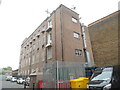
Fulham Telephone Exchange (2)
Taken from North End Road, this photo shows the back of the TE with a jib on the roof above the two entrance doors where the equipment is delivered from outside. This TE used to have FULham telephone numbers until the late 1960s, but now has numbers beginning with 0207, the 0207 referring to the Inner London group of TEs. More recently, lines connected to the former TEs at Earl's Court (TQ2678) and West Kensington (TQ2479) have been transferred to the Fulham TE.
Image: © David Hillas
Taken: 29 Apr 2022
0.02 miles
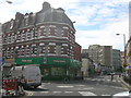
4
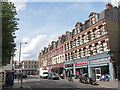
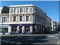
Shops at corner of North End Road and Lillie Road
Image: © Robin Webster
Taken: 13 May 2012
0.02 miles
5
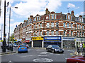
Lillie Road, SW6
Lillie Road looking towards North End Road.
Image: © Phillip Perry
Taken: 9 Jun 2008
0.02 miles
6
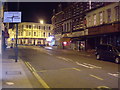
Lillie Road SW6
Looking across the junction with North End Road SW6
Image: © Robin Sones
Taken: 26 Aug 2009
0.03 miles
7
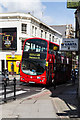
28 to Wandsworth
Once one of the longest routes in London stretching from Golders Green to Kingston Vale the route was split in the late 1980's to improve reliability. After a number of subsequent changes the route currently runs between Kensal Rise and Wandsworth. The route has a special timetable on days when Chelsea FC are playing at home. Here is one of Tower Transit's Volvo B7TL vehicles on North End Road - a bottleneck of congestion along the route.
Image: © Martin Addison
Taken: 11 Jun 2014
0.03 miles
8
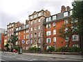
Philanthropic dwellings, Lillie Road, SW6
Names over the entrances identify 'Block A' and 'Block B' - rather heartlessly, it seems to me - as if this were a penal colony. Looking at the style of the block, my guess was that these are (or were) Peabody buildings - and other contributions confirm that this is the case. They must date from about 1900.
On a Friday evening in August the street was rather busier than the image suggests - I waited for a gap in pedestrian traffic.
Image: © Stefan Czapski
Taken: 13 Aug 2021
0.03 miles
9
Junction of Lillie Road and North End Road
Image: © David Martin
Taken: 26 Mar 2012
0.04 miles
10
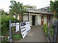
Polling Station, Community Hall, 80 Lillie Road
Image: © Oast House Archive
Taken: 7 May 2015
0.04 miles