IMAGES TAKEN NEAR TO
Nevern Place, LONDON, SW5 9PR
Introduction
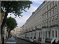
This page details the photographs taken nearby to Nevern Place, SW5 9PR by members of the Geograph project.
The Geograph project started in 2005 with the aim of publishing, organising and preserving representative images for every square kilometre of Great Britain, Ireland and the Isle of Man.

There are currently over 7.5m images from over14,400 individuals and you can help contribute to the project by visiting https://www.geograph.org.uk
Image Map
Images are licensed for reuse under creativecommons.org/licenses/by-sa/2.0
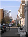
Notes
- Clicking on the map will re-center to the selected point.
- The higher the marker number, the further away the image location is from the centre of the postcode.
Image Listing (415 Images Found)
Images are licensed for reuse under creativecommons.org/licenses/by-sa/2.0
Image
Details
Distance
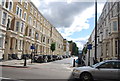
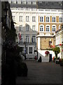
1
Nevern Place SW5 at junction of Templeton Place
Image: © Robin Sones
Taken: 18 Mar 2009
0.01 miles
3
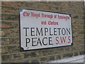
Defaced streetsign, Templeton Place SW5
Image: © Robin Sones
Taken: 11 Sep 2009
0.03 miles
5
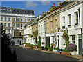
Spear Mews SW5
Looking towards the junction of Templeton Place
Image: © Robin Sones
Taken: 6 Aug 2010
0.03 miles
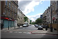
6
Kensington Park Hotel, Longridge Road, Earl's Court
Image: © PAUL FARMER
Taken: 30 Dec 2011
0.04 miles
8
View back up Nevern Square to Earls Court Road
Looking north-northeast.
Image: © Robert Lamb
Taken: 14 Jun 2014
0.04 miles
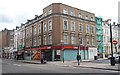
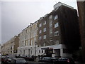
9
K&K Hotel George Kensington, 1-15 Templeton Place SW5
At the end of the road can be seen Trebovir Road SW5
Image: © Robin Sones
Taken: 5 May 2009
0.04 miles
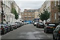
10
Spear Mews, Earl's Court
Looking down Spear Mews from Earl's Court Road.
Image: © Stephen McKay
Taken: 30 Apr 2013
0.04 miles