IMAGES TAKEN NEAR TO
Hogarth Place, LONDON, SW5 0QT
Introduction
This page details the photographs taken nearby to Hogarth Place, SW5 0QT by members of the Geograph project.
The Geograph project started in 2005 with the aim of publishing, organising and preserving representative images for every square kilometre of Great Britain, Ireland and the Isle of Man.

There are currently over 7.5m images from over14,400 individuals and you can help contribute to the project by visiting https://www.geograph.org.uk
Image Map
Images are licensed for reuse under creativecommons.org/licenses/by-sa/2.0
Notes
- Clicking on the map will re-center to the selected point.
- The higher the marker number, the further away the image location is from the centre of the postcode.
Image Listing (429 Images Found)
Images are licensed for reuse under creativecommons.org/licenses/by-sa/2.0
Image
Details
Distance
1
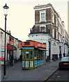
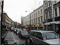
Hogarth Road Vicinity, Kensington, London
The apex of a triangular residential island. Hogarth Road continues ahead on the right of the picture, whereas on the left is a short pedestrian thoroughfare that links to Kenway Road. The King's Head public house is situated at the end of this alleyway. This interesting mobile phone shop, constructed of wood, seems likely to have had an interesting history.
Image: © David Hallam-Jones
Taken: 30 Dec 2014
0.01 miles
2
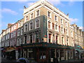
The Prince of Teck Public House, Earl's Court Road, London SW5
At Junction with Kenway Road, London SW5
Image: © Robin Sones
Taken: 2 Jan 2008
0.02 miles
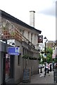
3
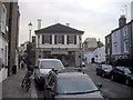
The Kings Head Public House Holgarth Place, Earls Court
Image: © PAUL FARMER
Taken: 6 Feb 2012
0.02 miles
8
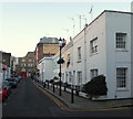
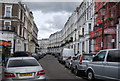
Kenway Road, Kensington, London
With The King's Head pub behind the photographer's left shoulder this a view along Kenway Road with the A3220 (i.e.Earl's Court Road) ahead. Wallgrave Road, where Willie Rushton - the English cartoonist, satirist, comedian, actor and performer, who co-founded the satirical magazine Private Eye once lived, is visible on the right.
Image: © David Hallam-Jones
Taken: 30 Dec 2014
0.03 miles
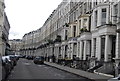
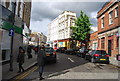
9
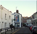
Kenway Road, Kensington, London
With the A3220 (Earl's Court Road) behind the photographer, this is the mid-point along Kenway Road. Once past the side of The King's Head pub - on the right - the road broadens out in front of the pub forming an area known locally as Hogarth Place, despite the fact that it is actually part of Kenway Road. The painting of the angel pouring water into a tiered fountain is on the side of No. 35 Kenway, Road, a 3-storey terrace built c.1807. The road branching off to the left is Wallgrave Road, where Willie Rushton once lived.
Image: © David Hallam-Jones
Taken: 30 Dec 2014
0.03 miles