IMAGES TAKEN NEAR TO
Abbeville Road, LONDON, SW4 9BH
Introduction
This page details the photographs taken nearby to Abbeville Road, SW4 9BH by members of the Geograph project.
The Geograph project started in 2005 with the aim of publishing, organising and preserving representative images for every square kilometre of Great Britain, Ireland and the Isle of Man.

There are currently over 7.5m images from over14,400 individuals and you can help contribute to the project by visiting https://www.geograph.org.uk
Image Map
Images are licensed for reuse under creativecommons.org/licenses/by-sa/2.0
Notes
- Clicking on the map will re-center to the selected point.
- The higher the marker number, the further away the image location is from the centre of the postcode.
Image Listing (87 Images Found)
Images are licensed for reuse under creativecommons.org/licenses/by-sa/2.0
Image
Details
Distance
6
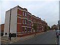
Park Court, Abbeville Road, Clapham
A block of twentieth century flats; the southern end of Abbeville Road was developed before this northern end, despite this latter being closer to the centre of London
Image: © David Smith
Taken: 28 Nov 2013
0.05 miles
8
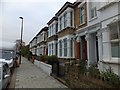
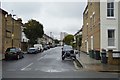
Terraced houses in Abbeville Road, Clapham
A row of houses with decorated porches and window surrounds; part of the development of Clapham at the end of the 19th century
Image: © David Smith
Taken: 28 Nov 2013
0.08 miles
10
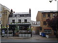
The King's Head Public House, Clapham
On Clapham Park Road.
Image: © David Anstiss
Taken: 3 Jun 2012
0.09 miles