IMAGES TAKEN NEAR TO
Moberly Road, LONDON, SW4 8EZ
Introduction
This page details the photographs taken nearby to Moberly Road, SW4 8EZ by members of the Geograph project.
The Geograph project started in 2005 with the aim of publishing, organising and preserving representative images for every square kilometre of Great Britain, Ireland and the Isle of Man.

There are currently over 7.5m images from over14,400 individuals and you can help contribute to the project by visiting https://www.geograph.org.uk
Image Map (Loading...)


Getting Data...Please wait
Leaflet Map data © OpenStreetMap
Images are licensed for reuse under creativecommons.org/licenses/by-sa/2.0
Notes
- Clicking on the map will re-center to the selected point.
- The higher the marker number, the further away the image location is from the centre of the postcode.
Image Listing (35 Images Found)
Images are licensed for reuse under creativecommons.org/licenses/by-sa/2.0
Image
Details
Distance
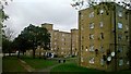
1
Clapham Park Estate, Plummer Road
The zig-zag barrier blocks facing Poynders Road looks 1950s so for the London County Council. Their future is uncertain. A lot of this estate has been pulled down in recent years and 2,500 new "affordable" homes are being built.
Image: © Stephen Richards
Taken: 11 Mar 2020
0.05 miles
2

A205, Poynders Road, SW4
The South Circular Road.
Image: © Robin Webster
Taken: 19 Apr 2019
0.08 miles
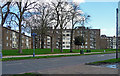
3
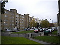
Apartment block on Muller Road
Old style housing block, close to King's Avenue.
Image: © David Anstiss
Taken: 2 Oct 2011
0.09 miles
4
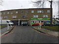
Shopping Precinct
Shopping precinct off Poynders Road.
Image: © Alan Hughes
Taken: 20 Jan 2018
0.09 miles
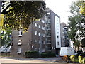
5
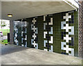
Detail of Tresidder House, Poynders Road
Modernist architects eschewing decoration as usual.
Image: © Stephen Richards
Taken: 11 Mar 2020
0.10 miles
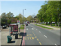
7
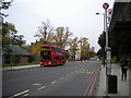
Poynder's Road, Clapham Park
Seen from the eastbound bus stop at which buses on the 45 (to King's Cross) and 57 (to Kingston) begin their journeys. One of the latter, in the form of a London United Dennis Trident/Alexander ALX400, is laying over in a layby apparently on the wrong side of the road; in fact, this section of Poynder's Road is one way, forming one side of a sort of triangular roundabout. The building to the left of the bus is a toilet block, now apparently exclusively for the use of bus drivers.
Image: © Richard Vince
Taken: 24 Oct 2015
0.11 miles
8
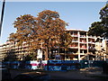
Development site on King's Avenue
This modern apartment building is being built on the site of some former 60's blocks of flats.
Image: © David Anstiss
Taken: 2 Oct 2011
0.12 miles
9
A205, Poynders Road, SW4
The South Circular Road by the westbound Poynders Road - Clarence Avenue bus stop.
Image: © Robin Webster
Taken: 19 Apr 2019
0.12 miles