IMAGES TAKEN NEAR TO
Kings Avenue, LONDON, SW4 8EE
Introduction
This page details the photographs taken nearby to Kings Avenue, SW4 8EE by members of the Geograph project.
The Geograph project started in 2005 with the aim of publishing, organising and preserving representative images for every square kilometre of Great Britain, Ireland and the Isle of Man.

There are currently over 7.5m images from over14,400 individuals and you can help contribute to the project by visiting https://www.geograph.org.uk
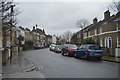
Image Map
Images are licensed for reuse under creativecommons.org/licenses/by-sa/2.0
Notes
- Clicking on the map will re-center to the selected point.
- The higher the marker number, the further away the image location is from the centre of the postcode.
Image Listing (48 Images Found)
Images are licensed for reuse under creativecommons.org/licenses/by-sa/2.0
Image
Details
Distance
1
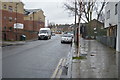
Looking down Clarence Avenue from Kings Avenue
Image: © Christopher Hilton
Taken: 28 Oct 2013
0.08 miles
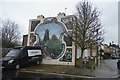
6

Rosebery Road, SW2
A street of terraced brick houses curving away from Kings Avenue.
Image: © Derek Harper
Taken: 13 Jan 2011
0.10 miles
7
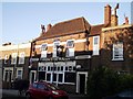
Prince of Wales, Public House, Brixton
On Lyham Road.
Image: © David Anstiss
Taken: 2 Oct 2011
0.10 miles
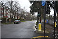
9
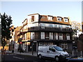
Former Duke of Cornwall, Public House, Brixton
On 89 Lyham Road, now converted to residential use.
Now called Blenheim Gardens.
Image: © David Anstiss
Taken: 2 Oct 2011
0.10 miles