IMAGES TAKEN NEAR TO
Studley Road, LONDON, SW4 6RX
Introduction
This page details the photographs taken nearby to Studley Road, SW4 6RX by members of the Geograph project.
The Geograph project started in 2005 with the aim of publishing, organising and preserving representative images for every square kilometre of Great Britain, Ireland and the Isle of Man.

There are currently over 7.5m images from over14,400 individuals and you can help contribute to the project by visiting https://www.geograph.org.uk
Image Map (Loading...)


Getting Data...Please wait
Leaflet Map data © OpenStreetMap
Images are licensed for reuse under creativecommons.org/licenses/by-sa/2.0
Notes
- Clicking on the map will re-center to the selected point.
- The higher the marker number, the further away the image location is from the centre of the postcode.
Image Listing (181 Images Found)
Images are licensed for reuse under creativecommons.org/licenses/by-sa/2.0
Image
Details
Distance
2
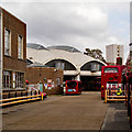
Stockwell Bus Garage
Grade II* listed bus garage built in the early 1950s to the designs of architects Adie Button & Partners. More at this https://www.architecture.com/Explore/Buildings/StockwellBusGarage.aspx. Architectural description at this https://www.historicengland.org.uk/listing/the-list/list-entry/1249757.
Image: © Jim Osley
Taken: 23 Oct 2016
0.05 miles
3
Stockwell Bus Garage
Hailed by the 20th Century Society as " one of the finest examples of post war modernist architecture". Grade II* listed - see this https://www.historicengland.org.uk/listing/the-list/list-entry/1249757.
Image: © Jim Osley
Taken: 23 Oct 2016
0.05 miles
4

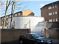
Sign for Recall, Stockwell deep shelter (south), Studley Road, SW4
In late 1940, the government decided to build a system of deep (air raid) shelters linked to existing underground stations. Each deep shelter consisted of two parallel tubes that might be used for future express underground lines. Seven such shelters were built at Northern Line stations - Belsize Park, Camden Town, Goodge Street, Stockwell, Clapham North, Clapham Common and Clapham South. Each shelter had two entrances with a “pill box” and ventilation shafts; most of these are still there today (February 2011). Some of the deep shelters are in use for secure storage of documents.
The shelter is currently (February 2011) used by Recall, a company that offers “document management services” http://www.recalldms.co.uk/index.html ; it is a Brambles Company http://www.brambles.com/BXB/content/home.html . The location of this sign is shown in Image
This shelter can be seen on the satellite image http://wtp2.appspot.com/wheresthepath.htm?lat=51.471519809720704&lon=-0.12407362461090088&gz=19&oz=10>=1 . [Source: “Beneath the City Streets” by Peter Laurie (1970, revised 1979).]
Image: © Mike Quinn
Taken: 8 Feb 2011
0.07 miles
5
Stockwell deep shelter (south), Studley Road, SW4
In late 1940, the government decided to build a system of deep (air raid) shelters linked to existing underground stations. Each deep shelter consisted of two parallel tubes that might be used for future express underground lines. Seven such shelters were built at Northern Line stations - Belsize Park, Camden Town, Goodge Street, Stockwell, Clapham North, Clapham Common and Clapham South. Each shelter had two entrances with a “pill box” and ventilation shafts; most of these are still there today (February 2011). Some of the deep shelters are in use for secure storage of documents.
The shelter is currently (February 2011) used by Recall (their name plate/logo is on the front of the pill box, centre) a company that offers “document management services” http://www.recalldms.co.uk/index.html ; it is a Brambles Company http://www.brambles.com/BXB/content/home.html .
This shelter can be seen on the satellite image http://wtp2.appspot.com/wheresthepath.htm?lat=51.471519809720704&lon=-0.12407362461090088&gz=19&oz=10>=1 . [Source: “Beneath the City Streets” by Peter Laurie (1970, revised 1979).]
Image: © Mike Quinn
Taken: 8 Feb 2011
0.07 miles
6
Stockwell deep shelter (south), Studley Road, SW4 (2)
In late 1940, the government decided to build a system of deep (air raid) shelters linked to existing underground stations. Each deep shelter consisted of two parallel tubes that might be used for future express underground lines. Seven such shelters were built at Northern Line stations - Belsize Park, Camden Town, Goodge Street, Stockwell, Clapham North, Clapham Common and Clapham South. Each shelter had two entrances with a “pill box” and ventilation shafts; most of these are still there today (February 2011). Some of the deep shelters are in use for secure storage of documents.
The shelter is currently (February 2011) used by Recall, a company that offers “document management services” http://www.recalldms.co.uk/index.html ; it is a Brambles Company http://www.brambles.com/BXB/content/home.html .
This shelter can be seen on the satellite image http://wtp2.appspot.com/wheresthepath.htm?lat=51.471519809720704&lon=-0.12407362461090088&gz=19&oz=10>=1 . [Source: “Beneath the City Streets” by Peter Laurie (1970, revised 1979).]
Image: © Mike Quinn
Taken: 8 Feb 2011
0.07 miles
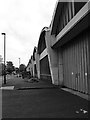
7
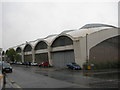
Stockwell Bus Garage (1)
Picture taken at the corner of Binfield Road and Lansdowne Way. This depot was opened in 1952. At the time of construction it was the largest unsupported area under one roof in Europe. It is now a Grade II listed building. Click this link to read more http://en.wikipedia.org/wiki/Stockwell_Garage
Image: © Danny P Robinson
Taken: 1 Oct 2007
0.07 miles
8

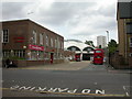
Escalators, Stockwell Underground Station SW4
Image: © Robin Sones
Taken: 29 Nov 2011
0.07 miles
9
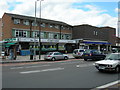
Stockwell Station
Looking across Clapham Road SW9. Between the supermarket and the station is a memorial to Jean Charles de Menezes, a man who was shot dead by police who mistakenly believed he was a terrorist. The incident took place on the station platform. Here is a view of the memorial
http://www.geograph.org.uk/photo/189737
Image: © Danny P Robinson
Taken: 20 Jun 2006
0.07 miles
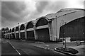
10
Stockwell Bus Garage
Off Binfield Road; opened 1952, with the largest single span roof in Europe. Managed by London General.
Image: © Mike Faherty
Taken: 22 Aug 2009
0.07 miles