IMAGES TAKEN NEAR TO
Clapham Road Estate, LONDON, SW4 6NA
Introduction
This page details the photographs taken nearby to Clapham Road Estate, SW4 6NA by members of the Geograph project.
The Geograph project started in 2005 with the aim of publishing, organising and preserving representative images for every square kilometre of Great Britain, Ireland and the Isle of Man.

There are currently over 7.5m images from over14,400 individuals and you can help contribute to the project by visiting https://www.geograph.org.uk
Image Map (Loading...)


Getting Data...Please wait
Leaflet Map data © OpenStreetMap
Images are licensed for reuse under creativecommons.org/licenses/by-sa/2.0
Notes
- Clicking on the map will re-center to the selected point.
- The higher the marker number, the further away the image location is from the centre of the postcode.
Image Listing (220 Images Found)
Images are licensed for reuse under creativecommons.org/licenses/by-sa/2.0
Image
Details
Distance
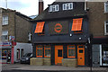
1
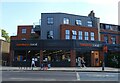
Love of Christ Generation Church
Grade II listed. https://www.britishlistedbuildings.co.uk/101422538-church-of-st-bede-and-institute-larkhall-ward
Image: © N Chadwick
Taken: 3 Feb 2018
0.02 miles
2

The Love of Christ Generation Church, Clapham Road
In the former St Bede's church
Image: © David Smith
Taken: 17 Nov 2016
0.02 miles
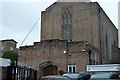
3

Clapham: St.Bede's Church for Deaf People
One of very few London churches specially equipped for the deaf.
Image: © Dr Neil Clifton
Taken: 11 Jul 2012
0.03 miles
4
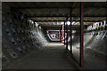
Clapham North Deep Level Shelter
The lower level of the deep level air raid shelter at Clapham North that was constructed below the Northern line and opened in 1944. Disused at the time the picture was taken but in 2014 the tunnel was leased by the Zero Carbon Food company, who use the shelter as a hydroponic farm.
Image: © Noel Jenkins
Taken: Unknown
0.04 miles

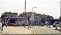
6
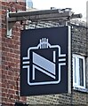
Sign for the Clapham North public house
See Image] for public house.
Image: © JThomas
Taken: 29 Jul 2022
0.04 miles
8
Entrance to Clapham North Underground station
View SW, towards Morden on the Northern Line; junction of Bedford Road (left) with Clapham High Street (right). The bridge ahead carries the SR from Victoria (ex-LC&DR main line and ex-LB&SCR South London line), just east of Clapham High Street station.
Image: © Ben Brooksbank
Taken: 8 Jul 1984
0.04 miles
9
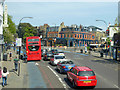
A3, Clapham Road, by Clapham North station
The Underground station is to the right, the pub on the corner has taken the same name.
Image: © Robin Webster
Taken: 19 Apr 2019
0.04 miles