IMAGES TAKEN NEAR TO
Edgeley Road, LONDON, SW4 6EP
Introduction
This page details the photographs taken nearby to Edgeley Road, SW4 6EP by members of the Geograph project.
The Geograph project started in 2005 with the aim of publishing, organising and preserving representative images for every square kilometre of Great Britain, Ireland and the Isle of Man.

There are currently over 7.5m images from over14,400 individuals and you can help contribute to the project by visiting https://www.geograph.org.uk
Image Map (Loading...)


Getting Data...Please wait
Leaflet Map data © OpenStreetMap
Images are licensed for reuse under creativecommons.org/licenses/by-sa/2.0
Notes
- Clicking on the map will re-center to the selected point.
- The higher the marker number, the further away the image location is from the centre of the postcode.
Image Listing (234 Images Found)
Images are licensed for reuse under creativecommons.org/licenses/by-sa/2.0
Image
Details
Distance
1
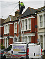
Telephone repairs on Edgeley Road
Wooden poles still distribute telephone lines to many suburban houses as here in Clapham, requiring the BT engineer to have a good head for heights.
Image: © Stephen McKay
Taken: 9 Oct 2009
0.01 miles
2
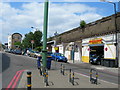
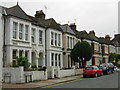
Voltaire Road SW4
Near Clapham High Street, looking towards Clapham High Street station.
Image: © Danny P Robinson
Taken: 21 Jun 2006
0.02 miles
3
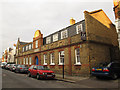
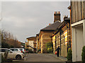
Pearson Mews
Brick built mews houses on Edgeley Road.
Image: © Stephen Craven
Taken: 13 Jan 2013
0.03 miles
4
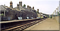
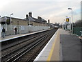
Clapham High Street station
This station opened in 1862 on the South London line as Clapham. It underwent various name-changes over the years, before reverting to the plain 'Clapham' in recent memory. But then the 'High Street' suffix was added, presumably to avoid confusion with Clapham Junction.
Image: © Dr Neil Clifton
Taken: 11 Jul 2012
0.04 miles
5
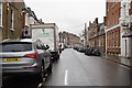
Edgeley Road, Clapham
Seen here at the junction with Voltaire Road.
Image: © Stephen McKay
Taken: 9 Oct 2009
0.05 miles
6
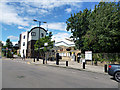
Former station buildings at Clapham High Street
Sadly, the elegant original station buildings (listed grade 2, list entry number 1338851) are now converted to housing, and a gated development with a high boundary wall at that, so this is the closest view from a public place.
Image: © Stephen Craven
Taken: 13 Jan 2013
0.05 miles
7
Clapham (later High Street) station, 1984
View NW, towards Victoria: ex-LB&SC South London line from London Bridge via Denmark Hill; also, passing on the right is the ex-LC&DR Victoria - Chatham - Kent Coast main line. It was to be named 'Clapham High Street' from 15/5/89.
Image: © Ben Brooksbank
Taken: 8 Jul 1984
0.05 miles
9

Clapham High Street station
Looking southeast. Trains in this direction go to London Bridge.
Image: © Dr Neil Clifton
Taken: 11 Jul 2012
0.05 miles
10
Clapham High Street railway station
Opened in 1862 by the London Chatham and Dover Railway, this side of the station was later run by the London Brighton and South Coast Railway while the LC&DR used two more platforms to the extreme right between 1867 and 1916. View north west towards London Victoria and Clapham Junction, from a similar position to Image
Image: © Nigel Thompson
Taken: 19 Mar 2013
0.05 miles