IMAGES TAKEN NEAR TO
Sycamore Mews, LONDON, SW4 0SY
Introduction
This page details the photographs taken nearby to Sycamore Mews, SW4 0SY by members of the Geograph project.
The Geograph project started in 2005 with the aim of publishing, organising and preserving representative images for every square kilometre of Great Britain, Ireland and the Isle of Man.

There are currently over 7.5m images from over14,400 individuals and you can help contribute to the project by visiting https://www.geograph.org.uk
Image Map (Loading...)


Getting Data...Please wait
Leaflet Map data © OpenStreetMap
Images are licensed for reuse under creativecommons.org/licenses/by-sa/2.0
Notes
- Clicking on the map will re-center to the selected point.
- The higher the marker number, the further away the image location is from the centre of the postcode.
Image Listing (135 Images Found)
Images are licensed for reuse under creativecommons.org/licenses/by-sa/2.0
Image
Details
Distance
1
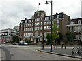
Clapham, Maritime House
On Old Town, opposite Image; built 1939 as headquarters of the National Union of Seamen, now owned by its successor, RMT Union. Used as flats for union members, solicitors' offices & a job centre.
Image: © Mike Faherty
Taken: 16 Aug 2009
0.07 miles
2
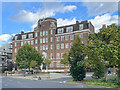
Maritime House
Building in Old Town designed by P G Bentham as the headquarters for the National Union of Seamen, built in 1939.
Image: © Ian Capper
Taken: 7 Oct 2022
0.07 miles
3
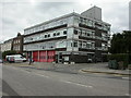
Clapham Fire Station
On Old Town, at the junction with Grafton Square; built 1964.
Image: © Mike Faherty
Taken: 16 Aug 2009
0.07 miles
4
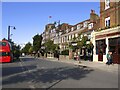
Clapham Old Town
There are Georgian houses here of a kind to be found in just a few parts of London. I'm reminded of Lincoln, or perhaps Blandford.
A flag can be seen flying against the blue sky. The tower must, I suppose, belong to the fire station - and the flag, oddly enough, is the Red Ensign.
The bus was one of three standing at the bus terminus.
Image: © Stefan Czapski
Taken: 29 Sep 2021
0.08 miles
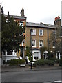
5
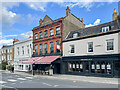
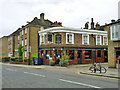
The Pig's Head and 1 & 3 Old Town
The Pig's Head, on the left, is a 19th Century pub which has gone through various names over the years: originally the Bull's Head, then the Friesian & Firkin, then the Calf, then the Rectory, before being given its current name in November 2021.
1 & 3 Old Town, on the right, was built around 1700 and is grade II listed - see https://historicengland.org.uk/listing/the-list/list-entry/1064998?section=official-list-entry.
Image: © Ian Capper
Taken: 7 Oct 2022
0.08 miles
7
Clapham Library
On North Side; the building is dated 1889. http://www.lambeth.gov.uk/Services/LeisureCulture/Libraries/LocalLibraries/ClaphamLibrary.htm
Image: © Mike Faherty
Taken: 15 Jul 2009
0.09 miles
8
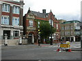
The former North Pole pub
Its current reincarnation is as something involving Mongolian grills and hot-pots.
Image: © Robin Webster
Taken: 6 May 2012
0.09 miles
9
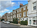
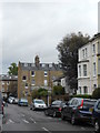
Rectory Grove
18th or 19th Century housing in Rectory Grove.
Image: © Ian Capper
Taken: 7 Oct 2022
0.10 miles