IMAGES TAKEN NEAR TO
Turret Grove, LONDON, SW4 0ES
Introduction
This page details the photographs taken nearby to Turret Grove, SW4 0ES by members of the Geograph project.
The Geograph project started in 2005 with the aim of publishing, organising and preserving representative images for every square kilometre of Great Britain, Ireland and the Isle of Man.

There are currently over 7.5m images from over14,400 individuals and you can help contribute to the project by visiting https://www.geograph.org.uk
Image Map (Loading...)


Getting Data...Please wait
Leaflet Map data © OpenStreetMap
Images are licensed for reuse under creativecommons.org/licenses/by-sa/2.0
Notes
- Clicking on the map will re-center to the selected point.
- The higher the marker number, the further away the image location is from the centre of the postcode.
Image Listing (147 Images Found)
Images are licensed for reuse under creativecommons.org/licenses/by-sa/2.0
Image
Details
Distance
1
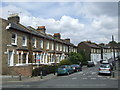
Turret Grove, SW4
Turret Grove, a residential street in Clapham, South London.
Image: © Malc McDonald
Taken: 30 May 2011
0.01 miles
2
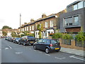
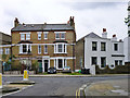
Houses in Broadhinton Road
Looking towards Rozel Road.
Image: © Rod Allday
Taken: 7 Oct 2016
0.06 miles

5
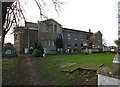
Garden of Remembrance, St. Paul's churchyard
Image: © Robin Webster
Taken: 6 May 2012
0.08 miles


9
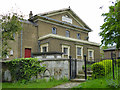
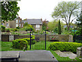
St Paul's, Clapham - west end
A grade II*(star) listed building, 1815 on the site of an older church, with 1879 east end. The listing refers to a plaque at this end reading "1815 ST PAULS CHURCH" which is wrong. As may be seen, the plaque reads "1815 ST PAULS CHAPEL".
Image: © Robin Webster
Taken: 6 May 2012
0.08 miles
10
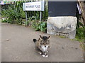
Cat at Matrimony Place
Matrimony Place is a narrow passageway which leads up steps from Wandsworth Road between St Pauls Churchyard and the Eden Garden before eventually reaching Iveley Road. It is just a few yards from the wonderful National Trust property of 575 Wandsworth Road - see https://www.nationaltrust.org.uk/575-wandsworth-road
Image: © Marathon
Taken: 24 May 2019
0.08 miles