IMAGES TAKEN NEAR TO
Lambeth, LONDON, SW3 6WX

Introduction

This page details the photographs taken nearby to SW3 6WX by members of the Geograph project.

The Geograph project started in 2005 with the aim of publishing, organising and preserving representative images for every square kilometre of Great Britain, Ireland and the Isle of Man.

There are currently over 7.5m images from over14,400 individuals and you can help contribute to the project by visiting https://www.geograph.org.uk

Image Map


Images are licensed for reuse under creativecommons.org/licenses/by-sa/2.0
Notes
  • Clicking on the map will re-center to the selected point.
  • The higher the marker number, the further away the image location is from the centre of the postcode.

Image Listing (278 Images Found)

Images are licensed for reuse under creativecommons.org/licenses/by-sa/2.0
  • ...
Image
Details
Distance
1
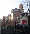
Clapham Delivery Office
With the words "Postmens Office" above the red door, and a plaque with the date 1902 in fanciful script, this rather charming little building is beside the right-angled bend on Venn Street, beside Sedley Place. This wasn't really the time of day for this photo with the sun low behind the subject. ED: See also http://www.geograph.org.uk/search.php?i=54051562 .
Image: © Derek Harper Taken: 8 Feb 2015
0.00 miles
2
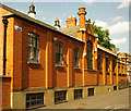
Clapham Sorting Office (1902)
Side elevation.
Image: © Jim Osley Taken: 26 Aug 2013
0.02 miles
3
Clapham Sorting Office (1902)
Staff entrance.
Image: © Jim Osley Taken: 26 Aug 2013
0.02 miles
4
Clapham Sorting Office (1902)
Probably the most idiosyncratic of the Edwardian sorting offices in the Greater London area.
Image: © Jim Osley Taken: 26 Aug 2013
0.02 miles
5
Clapham Community Project
The project is based in this building on Bromell's Road, and according to the Lambeth borough website it "provides confidential advice on welfare benefits, employment, debt, housing, consumer and legal issues." The building dates from 1895 Image
Image: © Stephen Craven Taken: 13 Jan 2013
0.03 miles
6
Foundation stone, 31 Bromell's Road, Clapham
The stone records is dated 1895. The building now houses the Clapham Community Project Image
Image: © Stephen Craven Taken: 13 Jan 2013
0.03 miles
7
Bromell's Road, Clapham
The northwest side of the street. The building without bays is Image
Image: © Derek Harper Taken: 8 Feb 2015
0.04 miles
8
Houses near Clapham Common station
The crossroads of Bromell's Road (foreground) with Venn Street. On the extreme left is Image
Image: © Derek Harper Taken: 8 Feb 2015
0.04 miles
9
Clapham Community Project
In the former St Anne's Hall, dating from 1895 - see Image and Image This is the building on the left of Image
Image: © Derek Harper Taken: 8 Feb 2015
0.04 miles
10
Venn Street, Clapham
Taken a few metres along the road shown in Image], and getting on for three hours and a big lunch later.
Image: © Derek Harper Taken: 8 Feb 2015
0.05 miles
  • ...