IMAGES TAKEN NEAR TO
Kings Road, LONDON, SW3 5UA
Introduction
This page details the photographs taken nearby to Kings Road, SW3 5UA by members of the Geograph project.
The Geograph project started in 2005 with the aim of publishing, organising and preserving representative images for every square kilometre of Great Britain, Ireland and the Isle of Man.

There are currently over 7.5m images from over14,400 individuals and you can help contribute to the project by visiting https://www.geograph.org.uk
Image Map
Images are licensed for reuse under creativecommons.org/licenses/by-sa/2.0
Notes
- Clicking on the map will re-center to the selected point.
- The higher the marker number, the further away the image location is from the centre of the postcode.
Image Listing (378 Images Found)
Images are licensed for reuse under creativecommons.org/licenses/by-sa/2.0
Image
Details
Distance
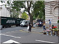
1
John Nicholson Auctioneers, Kings Road SW3
At the junction with Sydney Street
Image: © Robin Sones
Taken: 10 Oct 2010
0.02 miles
2
Former post office, King's Road, Chelsea
Built 1905 to the designs of Office of Works architect Jasper Wager.
Image: © Jim Osley
Taken: 19 Aug 2011
0.02 miles
5
Junction of Chelsea Manor Street and Kings Road
Image: © Basher Eyre
Taken: 2 Aug 2014
0.02 miles
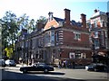
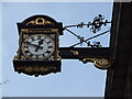
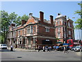
6
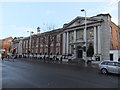
Chelsea Library and Town Hall, King's Road SW3
Taken from the junction with Sydney Street
Image: © Robin Sones
Taken: 5 Jan 2012
0.03 miles
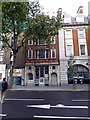
7
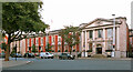
Chelsea Old Town Hall
Town hall for the Metropolitan Borough of Chelsea, which functioned between 1900 and 1965.
Image: © Dylan Moore
Taken: 13 Oct 2023
0.03 miles
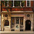
8
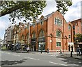
Chelsea Methodist Centre
On Kings Road. A plaque shows a date of 1903 as a Sunday School. http://www.chelseamethodist.org.uk/History.html
Image: © Mike Faherty
Taken: 20 Aug 2016
0.03 miles
9
250 King's Road
Currently a private clinic.
Image: © Oast House Archive
Taken: 27 May 2016
0.03 miles
10
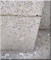
Ordnance Survey Cut Mark
This OS cut mark can be found on the north angle of the Town Hall. It marks a point 8.008m above mean sea level.
Image: © Adrian Dust
Taken: 30 Sep 2019
0.03 miles