IMAGES TAKEN NEAR TO
Chelsea Manor Street, LONDON, SW3 5RP
Introduction
This page details the photographs taken nearby to Chelsea Manor Street, SW3 5RP by members of the Geograph project.
The Geograph project started in 2005 with the aim of publishing, organising and preserving representative images for every square kilometre of Great Britain, Ireland and the Isle of Man.

There are currently over 7.5m images from over14,400 individuals and you can help contribute to the project by visiting https://www.geograph.org.uk
Image Map
Images are licensed for reuse under creativecommons.org/licenses/by-sa/2.0
Notes
- Clicking on the map will re-center to the selected point.
- The higher the marker number, the further away the image location is from the centre of the postcode.
Image Listing (435 Images Found)
Images are licensed for reuse under creativecommons.org/licenses/by-sa/2.0
Image
Details
Distance
1
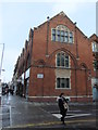
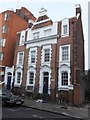
Former Wesleyan Methodist Sunday School, Chelsea Manor Street SW3
At the junction with King's Road
Image: © Robin Sones
Taken: 5 Jan 2012
0.02 miles
2
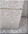
Ordnance Survey Cut Mark
This OS cut mark can be found on the north angle of the Town Hall. It marks a point 8.008m above mean sea level.
Image: © Adrian Dust
Taken: 30 Sep 2019
0.02 miles
3
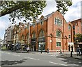
North end of Flood Street, SW3
A store called 'Anthropologie' has taken the place of the 'Antiquarius' antiques centre on the corner with King's Road Image Image
Image: © Robin Stott
Taken: 23 Apr 2010
0.02 miles
4
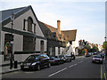
Chelsea Methodist Centre
On Kings Road. A plaque shows a date of 1903 as a Sunday School. http://www.chelseamethodist.org.uk/History.html
Image: © Mike Faherty
Taken: 20 Aug 2016
0.02 miles
5
Kensington and Chelsea Conservative Association, Chelsea Manor Street SW3
Image: © Robin Sones
Taken: 5 Jan 2012
0.03 miles
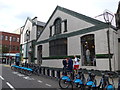
6

Chelsea Sports Centre, Chelsea Manor Street SW3
Image: © Robin Sones
Taken: 10 Oct 2010
0.03 miles
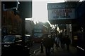
7
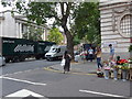
Junction of Chelsea Manor Street and Kings Road
Image: © Basher Eyre
Taken: 2 Aug 2014
0.03 miles
8
Approaching the junction of Flood Street and Kings Road
Image: © Basher Eyre
Taken: 2 Aug 2014
0.03 miles
9
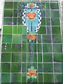
Tiles on a building at the top of Flood Street
Image: © Basher Eyre
Taken: 2 Aug 2014
0.03 miles
10
View down Kings Road
Looking south-southwest.
Image: © Robert Lamb
Taken: 30 Jan 2016
0.03 miles