IMAGES TAKEN NEAR TO
Sloane Court East, LONDON, SW3 4TQ
Introduction
This page details the photographs taken nearby to Sloane Court East, SW3 4TQ by members of the Geograph project.
The Geograph project started in 2005 with the aim of publishing, organising and preserving representative images for every square kilometre of Great Britain, Ireland and the Isle of Man.

There are currently over 7.5m images from over14,400 individuals and you can help contribute to the project by visiting https://www.geograph.org.uk
Image Map
Images are licensed for reuse under creativecommons.org/licenses/by-sa/2.0
Notes
- Clicking on the map will re-center to the selected point.
- The higher the marker number, the further away the image location is from the centre of the postcode.
Image Listing (548 Images Found)
Images are licensed for reuse under creativecommons.org/licenses/by-sa/2.0
Image
Details
Distance
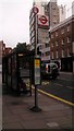
2
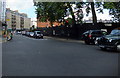
Lower Sloane Street, London SW1W
The A3216.
Image: © JThomas
Taken: 27 May 2022
0.01 miles
3

London Bus in Lower Sloane Street
The bus is advertising Candy Crush Soda Saga
Image: © PAUL FARMER
Taken: 9 Mar 2015
0.02 miles
4
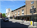
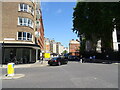
Businesses on Lower Sloane Street, London SW1W
Image: © JThomas
Taken: 27 May 2022
0.02 miles

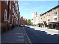
7
Pimlico Road, Chelsea
Taken at Junction with Chelsea Bridge Road
Image: © PAUL FARMER
Taken: 22 Aug 2012
0.03 miles
9
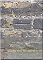
Ordnance Survey Cut Mark
This OS cut mark can be found on the wall SE side of Royal Hospital Road. It marks a point 4.768m above mean sea level.
Image: © Adrian Dust
Taken: 30 Sep 2019
0.04 miles
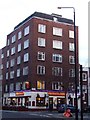
10
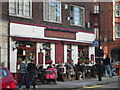
Rose & Crown, Lower Sloane Street SW1
At the junction with Turks Row
Image: © Robin Sones
Taken: 10 Oct 2010
0.04 miles