IMAGES TAKEN NEAR TO
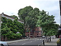
Cheyne Place, LONDON, SW3 4HL
Introduction
This page details the photographs taken nearby to Cheyne Place, SW3 4HL by members of the Geograph project.
The Geograph project started in 2005 with the aim of publishing, organising and preserving representative images for every square kilometre of Great Britain, Ireland and the Isle of Man.

There are currently over 7.5m images from over14,400 individuals and you can help contribute to the project by visiting https://www.geograph.org.uk
Image Map
Images are licensed for reuse under creativecommons.org/licenses/by-sa/2.0
Notes
- Clicking on the map will re-center to the selected point.
- The higher the marker number, the further away the image location is from the centre of the postcode.
Image Listing (536 Images Found)
Images are licensed for reuse under creativecommons.org/licenses/by-sa/2.0
Image
Details
Distance
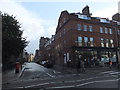
1
Approaching a zebra crossing in Royal Hospital Road
Image: © Basher Eyre
Taken: 2 Aug 2014
0.02 miles
2
Approaching the junction of Royal Hospital Road and Tite Street
Image: © Basher Eyre
Taken: 2 Aug 2014
0.02 miles
3
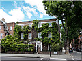
House in Cheyne Place, Royal Hospital Road, Chelsea, London
Image: © Christine Matthews
Taken: 14 Jul 2016
0.02 miles
4
Looking from Royal Hospital Road into Paradise Walk
Image: © Basher Eyre
Taken: 2 Aug 2014
0.02 miles
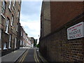
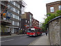
5
Tite Street SW3
At the junction with Royal Hospital Road
Image: © Robin Sones
Taken: 5 Jan 2012
0.03 miles
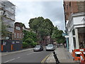
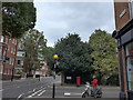
8
Looking across Royal Hospital Road towards Tite Street
Image: © Basher Eyre
Taken: 2 Aug 2014
0.04 miles
9
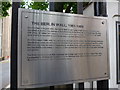
Plaque outside the National Army Museum
For more information see https://en.wikipedia.org/wiki/Berlin_Wall
Image: © Basher Eyre
Taken: 2 Aug 2014
0.04 miles
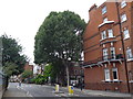
10
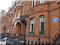
Blue plaque in Tite Street (1)
For more details see https://en.wikipedia.org/wiki/Peter_Warlock
Image: © Basher Eyre
Taken: 2 Aug 2014
0.04 miles