IMAGES TAKEN NEAR TO
Redburn Street, LONDON, SW3 4BX
Introduction
This page details the photographs taken nearby to Redburn Street, SW3 4BX by members of the Geograph project.
The Geograph project started in 2005 with the aim of publishing, organising and preserving representative images for every square kilometre of Great Britain, Ireland and the Isle of Man.

There are currently over 7.5m images from over14,400 individuals and you can help contribute to the project by visiting https://www.geograph.org.uk
Image Map
Images are licensed for reuse under creativecommons.org/licenses/by-sa/2.0
Notes
- Clicking on the map will re-center to the selected point.
- The higher the marker number, the further away the image location is from the centre of the postcode.
Image Listing (562 Images Found)
Images are licensed for reuse under creativecommons.org/licenses/by-sa/2.0
Image
Details
Distance
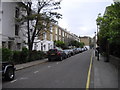
2
View up Redesdale Street
Looking north-northeast from Flood Street.
Image: © Robert Lamb
Taken: 30 Jan 2016
0.02 miles
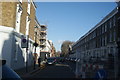
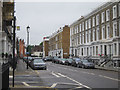
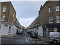
3
View up Redburn Street
Looking north-northeast from Flood Street.
Image: © Robert Lamb
Taken: 30 Jan 2016
0.03 miles
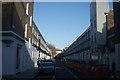
4
Looking from Flood Street into Redesdale Street
Image: © Basher Eyre
Taken: 2 Aug 2014
0.03 miles
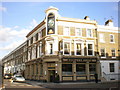
7
Coopers Arms, Flood Street SW3
At the junction with Redesdale Street
Image: © Robin Sones
Taken: 5 Jan 2012
0.04 miles
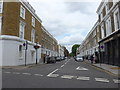
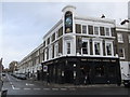
9
Redburn Street SW3
At the junction with Flood Street
Image: © Robin Sones
Taken: 5 Jan 2012
0.04 miles
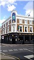
10
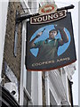
Pub sign, Coopers Arms, Flood Street SW3
Image: © Robin Sones
Taken: 5 Jan 2012
0.04 miles