IMAGES TAKEN NEAR TO
Astell Street, LONDON, SW3 3RT
Introduction
This page details the photographs taken nearby to Astell Street, SW3 3RT by members of the Geograph project.
The Geograph project started in 2005 with the aim of publishing, organising and preserving representative images for every square kilometre of Great Britain, Ireland and the Isle of Man.

There are currently over 7.5m images from over14,400 individuals and you can help contribute to the project by visiting https://www.geograph.org.uk
Image Map
Images are licensed for reuse under creativecommons.org/licenses/by-sa/2.0
Notes
- Clicking on the map will re-center to the selected point.
- The higher the marker number, the further away the image location is from the centre of the postcode.
Image Listing (394 Images Found)
Images are licensed for reuse under creativecommons.org/licenses/by-sa/2.0
Image
Details
Distance
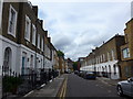
1
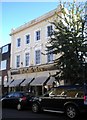
View up Godfrey Street
Looking north-northwest.
Image: © Robert Lamb
Taken: 30 Jan 2016
0.03 miles
2
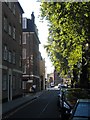
Godfrey Street SW3
Taken from Cale Street.
Image: © Danny P Robinson
Taken: 27 Jun 2006
0.03 miles
3
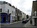
Britten Street SW3
Looking towards the junction with Chelsea Manor Street
Image: © Robin Sones
Taken: 10 Oct 2010
0.03 miles
4
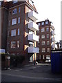
Rear of Astell House
Taken from Astell Street
Image: © PAUL FARMER
Taken: 1 Apr 2009
0.03 miles
6
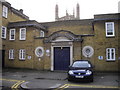
St Luke's Hall, St Luke's Street, Chelsea
The 142ft tower of St Luke's Church Sydney Street can be seen in the background.
Image: © PAUL FARMER
Taken: 17 Mar 2010
0.03 miles
10
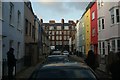
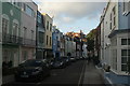
View of brightly coloured houses on Godfrey Street
Looking north-northwest.
Image: © Robert Lamb
Taken: 30 Jan 2016
0.04 miles