IMAGES TAKEN NEAR TO
Pavilion Road, LONDON, SW3 2BF
Introduction
This page details the photographs taken nearby to Pavilion Road, SW3 2BF by members of the Geograph project.
The Geograph project started in 2005 with the aim of publishing, organising and preserving representative images for every square kilometre of Great Britain, Ireland and the Isle of Man.

There are currently over 7.5m images from over14,400 individuals and you can help contribute to the project by visiting https://www.geograph.org.uk
Image Map
Images are licensed for reuse under creativecommons.org/licenses/by-sa/2.0
Notes
- Clicking on the map will re-center to the selected point.
- The higher the marker number, the further away the image location is from the centre of the postcode.
Image Listing (586 Images Found)
Images are licensed for reuse under creativecommons.org/licenses/by-sa/2.0
Image
Details
Distance
3
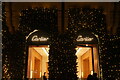
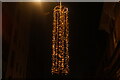
View of Christmas lights on the front of Cartier
Looking west.
Image: © Robert Lamb
Taken: 6 Dec 2020
0.02 miles
5
View of Christmas lights on Sloane Square
Looking west.
Image: © Robert Lamb
Taken: 6 Dec 2020
0.02 miles
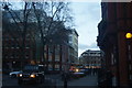
6
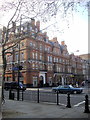
Junction of Sloane Avenue and Sloane Square
Image: © PAUL FARMER
Taken: 30 Mar 2012
0.03 miles
7
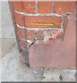
Ordnance Survey Cut Mark
This OS cut mark can be found on the wall of Holy Trinity School Yard. It marks a point 6.044m above mean sea level.
Image: © Adrian Dust
Taken: 30 Sep 2019
0.03 miles
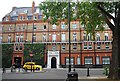
8
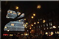
View of snowflakes in Sloane Square #3
Looking north-northwest.
Image: © Robert Lamb
Taken: 6 Dec 2020
0.03 miles
10
View down Cadogan Gardens from Draycott Place
Looking south-southeast.
Image: © Robert Lamb
Taken: 30 Jan 2016
0.03 miles