IMAGES TAKEN NEAR TO
Beaufort Gardens, LONDON, SW3 1PS
Introduction
This page details the photographs taken nearby to Beaufort Gardens, SW3 1PS by members of the Geograph project.
The Geograph project started in 2005 with the aim of publishing, organising and preserving representative images for every square kilometre of Great Britain, Ireland and the Isle of Man.

There are currently over 7.5m images from over14,400 individuals and you can help contribute to the project by visiting https://www.geograph.org.uk
Image Map
Images are licensed for reuse under creativecommons.org/licenses/by-sa/2.0
Notes
- Clicking on the map will re-center to the selected point.
- The higher the marker number, the further away the image location is from the centre of the postcode.
Image Listing (408 Images Found)
Images are licensed for reuse under creativecommons.org/licenses/by-sa/2.0
Image
Details
Distance
1
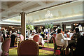
Harrods of London
High tea at Harrods store on Brompton Road, Knightsbridge, London.
Image: © Ann Harrison
Taken: 2 Jun 2012
0.04 miles
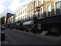
2
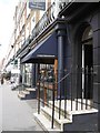
Beauchamp Place, looking towards Brompton Road
Image: © pam fray
Taken: 31 Mar 2008
0.04 miles