IMAGES TAKEN NEAR TO
Ashby Mews, LONDON, SW2 5EQ
Introduction
This page details the photographs taken nearby to Ashby Mews, SW2 5EQ by members of the Geograph project.
The Geograph project started in 2005 with the aim of publishing, organising and preserving representative images for every square kilometre of Great Britain, Ireland and the Isle of Man.

There are currently over 7.5m images from over14,400 individuals and you can help contribute to the project by visiting https://www.geograph.org.uk
Image Map
Images are licensed for reuse under creativecommons.org/licenses/by-sa/2.0
Notes
- Clicking on the map will re-center to the selected point.
- The higher the marker number, the further away the image location is from the centre of the postcode.
Image Listing (58 Images Found)
Images are licensed for reuse under creativecommons.org/licenses/by-sa/2.0
Image
Details
Distance
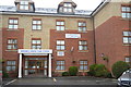
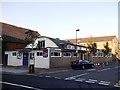
1
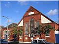
Kings Acre Methodist Church
Wesleyan Mission Chapel of 1886 on Lyham Road, now known as Kings Acre Methodist Church.
Image: © Stephen Craven
Taken: 21 Nov 2006
0.05 miles
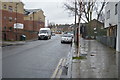
4
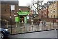
Lytham Road Youth Club.Brixton
On the junction of Lytham Road (in front) and Mandrell Road (on the left).
Image: © David Anstiss
Taken: 2 Oct 2011
0.06 miles