IMAGES TAKEN NEAR TO
Hayter Road, LONDON, SW2 5AS
Introduction
This page details the photographs taken nearby to Hayter Road, SW2 5AS by members of the Geograph project.
The Geograph project started in 2005 with the aim of publishing, organising and preserving representative images for every square kilometre of Great Britain, Ireland and the Isle of Man.

There are currently over 7.5m images from over14,400 individuals and you can help contribute to the project by visiting https://www.geograph.org.uk
Image Map
Images are licensed for reuse under creativecommons.org/licenses/by-sa/2.0
Notes
- Clicking on the map will re-center to the selected point.
- The higher the marker number, the further away the image location is from the centre of the postcode.
Image Listing (123 Images Found)
Images are licensed for reuse under creativecommons.org/licenses/by-sa/2.0
Image
Details
Distance
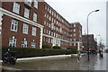
4
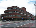
Olive Morris House, Brixton Hill
An exceedingly horizontal building, perhaps showing Scandinavian influences.
Offices of Lambeth Council.
Image: © Stephen Richards
Taken: 27 Apr 2013
0.12 miles
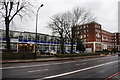
5
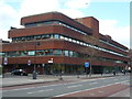
Olive Morris House, Brixton Road SW2
At the junction with Hayter Road. Part of the council offices.
Image: © Robin Sones
Taken: 17 Apr 2012
0.12 miles
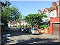
6
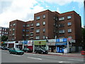
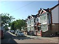
Arlington Parade and Arlington Court, SW2
This is on Brixton Hill, near Baytree Road.
Image: © Danny P Robinson
Taken: 20 Jun 2007
0.12 miles
7
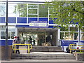
Brixton Centre entrance, Lambeth College, Brixton Hill SW2
Image: © Robin Sones
Taken: 17 Apr 2012
0.12 miles