IMAGES TAKEN NEAR TO
Rastell Avenue, LONDON, SW2 4XP
Introduction
This page details the photographs taken nearby to Rastell Avenue, SW2 4XP by members of the Geograph project.
The Geograph project started in 2005 with the aim of publishing, organising and preserving representative images for every square kilometre of Great Britain, Ireland and the Isle of Man.

There are currently over 7.5m images from over14,400 individuals and you can help contribute to the project by visiting https://www.geograph.org.uk
Image Map
Images are licensed for reuse under creativecommons.org/licenses/by-sa/2.0
Notes
- Clicking on the map will re-center to the selected point.
- The higher the marker number, the further away the image location is from the centre of the postcode.
Image Listing (81 Images Found)
Images are licensed for reuse under creativecommons.org/licenses/by-sa/2.0
Image
Details
Distance
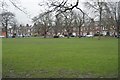
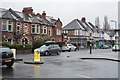
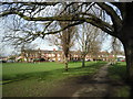
4
Houses facing Tooting Bec Common
This is the very northern edge of the Tooting Commons, bounded by Emmanuel Road. It is also the boundary of Wandsworth Borough where it meets Lambeth.
Image: © Bill Boaden
Taken: 1 Feb 2014
0.05 miles
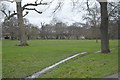
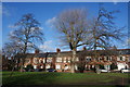
6
Tooting Bec Common
This is the far north-eastern corner of Tooting Bec Common, north of the railway line between Balham and Streatham Hill. The houses are in Emmanuel Road.
Image: © Marathon
Taken: 24 Feb 2011
0.05 miles
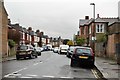
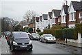
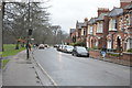
7
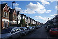
Sternhold Avenue
A stereotypical residential road in Telford Park.
Image: © Bill Boaden
Taken: 1 Feb 2014
0.06 miles