IMAGES TAKEN NEAR TO
Telford Avenue, LONDON, SW2 4XA
Introduction
This page details the photographs taken nearby to Telford Avenue, SW2 4XA by members of the Geograph project.
The Geograph project started in 2005 with the aim of publishing, organising and preserving representative images for every square kilometre of Great Britain, Ireland and the Isle of Man.

There are currently over 7.5m images from over14,400 individuals and you can help contribute to the project by visiting https://www.geograph.org.uk
Image Map
Images are licensed for reuse under creativecommons.org/licenses/by-sa/2.0
Notes
- Clicking on the map will re-center to the selected point.
- The higher the marker number, the further away the image location is from the centre of the postcode.
Image Listing (97 Images Found)
Images are licensed for reuse under creativecommons.org/licenses/by-sa/2.0
Image
Details
Distance
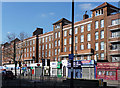
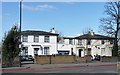
1
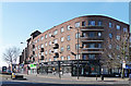
Telford Parade Mansions, Streatham Hill
Designed, like the neighbouring block, by Verity, Beverley and Homer in c1935. It curves round into Telford Avenue, and has a number of balconies, and shops on the ground floor. It is within the Streatham High Road and Streatham Hill Conservation Area.
The course of Streatham High Road has been a major highway between London and Sussex since Roman times. Its current appearance is largely attributable to two major spells of development. The first was during the late C19th following the opening of Streatham Hill station in 1856, and the second was after 1911 when the line to Victoria was electrified. Though much-maligned and undoubtedly blighted by heavy traffic, closer examination reveals that the road is lined with a number of interesting buildings, some of which reflect the period between the wars when Streatham was a fashionable centre of entertainment. Information from Lambeth Council (http://www.lambeth.gov.uk/NR/exeres/CE4B5CE1-0387-40ED-B5A9-273A5160C34A.htm ).
Image: © Stephen Richards
Taken: Unknown
0.00 miles
3
Telford Avenue Mansions, Telford Avenue
Designed by Frank Verity, Beverley and Homer in c1935. A typical 30s block of flats with metal Crittall windows, and "attractive sunray metalwork" above the front doors. It is within the Streatham High Road and Streatham Hill Conservation Area.
Information from Lambeth Council (http://www.lambeth.gov.uk/NR/exeres/CE4B5CE1-0387-40ED-B5A9-273A5160C34A.htm ).
Image: © Stephen Richards
Taken: Unknown
0.01 miles
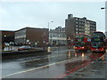
5
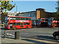
Bus leaving Brixton Garage
Fleet number DW68 is displaying blinds for route 137 to Marble Arch. DW234 and DW81 are parked flanking the garage exit.
Image: © Robin Webster
Taken: 19 Nov 2011
0.02 miles
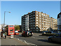
6
Telford Court, Streatham Hill
A sizeable block of flats, with shops, designed by Frank Harrington in 1931. The most distinctive features are the four pantiled belvederes with arched openings. It is within the Streatham High Road and Streatham Hill Conservation Area.
The course of Streatham High Road has been a major highway between London and Sussex since Roman times. Its current appearance is largely attributable to two major spells of development. The first was during the late C19th following the opening of Streatham Hill station in 1856, and the second was after 1911 when the line to Victoria was electrified. Though much-maligned and undoubtedly blighted by heavy traffic, closer examination reveals that the road is lined with a number of interesting buildings, some of which reflect the period between the wars when Streatham was a fashionable centre of entertainment. Information from Lambeth Council (http://www.lambeth.gov.uk/NR/exeres/CE4B5CE1-0387-40ED-B5A9-273A5160C34A.htm ).
Image: © Stephen Richards
Taken: Unknown
0.03 miles
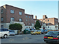
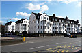
7
Corner Fielde
This is the name of the block of flats on the corner.
Image: © Robin Webster
Taken: 19 Nov 2011
0.03 miles
8
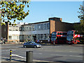
Arriva London South offices
At Brixton bus garage.
Image: © Robin Webster
Taken: 19 Nov 2011
0.04 miles
9
40, 42 and 44 Streatham Hill
A cluster of three early C19th survivals - some achievement on this road - villas in the Gothick style. The addition of the 'k' denotes the fact that the style is only superficial, being employed to keep up with the latest fashion. Scratch a Gothick building and (usually) a Classical one is revealed. Here, not much scratching is needed, the nod to Gothic being the pointed window tracery. Grade II listed.
Image: © Stephen Richards
Taken: Unknown
0.05 miles
10
Wavertree Court, Streatham Hill
Next to Corner Fielde, more large blocks of flats, though designed in a quite different style. By Frank Harrington in 1933, with Dutch-style shaped gables, mansard roofs, metal Crittall-style windows, and white rendered walls. It is within the Streatham High Road and Streatham Hill Conservation Area.
The course of Streatham High Road has been a major highway between London and Sussex since Roman times. Its current appearance is largely attributable to two major spells of development. The first was during the late C19th following the opening of Streatham Hill station in 1856, and the second was after 1911 when the line to Victoria was electrified. Though much-maligned and undoubtedly blighted by heavy traffic, closer examination reveals that the road is lined with a number of interesting buildings, some of which reflect the period between the wars when Streatham was a fashionable centre of entertainment. Information from Lambeth Council (http://www.lambeth.gov.uk/NR/exeres/CE4B5CE1-0387-40ED-B5A9-273A5160C34A.htm ).
Image: © Stephen Richards
Taken: Unknown
0.06 miles