IMAGES TAKEN NEAR TO
Kingswood Road, LONDON, SW2 4JL
Introduction
This page details the photographs taken nearby to Kingswood Road, SW2 4JL by members of the Geograph project.
The Geograph project started in 2005 with the aim of publishing, organising and preserving representative images for every square kilometre of Great Britain, Ireland and the Isle of Man.

There are currently over 7.5m images from over14,400 individuals and you can help contribute to the project by visiting https://www.geograph.org.uk
Image Map
Images are licensed for reuse under creativecommons.org/licenses/by-sa/2.0
Notes
- Clicking on the map will re-center to the selected point.
- The higher the marker number, the further away the image location is from the centre of the postcode.
Image Listing (79 Images Found)
Images are licensed for reuse under creativecommons.org/licenses/by-sa/2.0
Image
Details
Distance
1
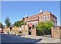
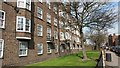
Brixton Hill, primary school
On New Park Road; an inscription announces it as LSB (London School Board) Brixton Hill School; now Richard Atkins Primary School. http://www.richard-atkins-primary.co.uk/
Image: © Mike Faherty
Taken: 18 Aug 2012
0.04 miles
2
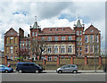
Richard Atkins School, Kingswood Road
A particularly florid Board school, characteristic of T.J. Bailey. Built in 1897 and 1903. Grade II listed.
Image: © Stephen Richards
Taken: 27 Apr 2013
0.04 miles
3
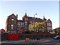
Richard Atkins Primary School, Streatham Hill
Grade II listed primary school on New Park Road.
See http://www.britishlistedbuildings.co.uk/en-204492-main-building-of-richard-atkins-junior-m for more details about the school.
Image: © David Anstiss
Taken: 2 Oct 2011
0.04 miles
6
67 and 69, New Park Road, Streatham Hill
Two Grade II listed houses on New Park Road.
See http://www.britishlistedbuildings.co.uk/en-204491-67-and-69-streatham for more details about the small buildings.
Image: © David Anstiss
Taken: 2 Oct 2011
0.06 miles
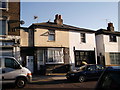
7
The Sultan, Public House, Streatham Hill
Pub on New Park Road.
Image: © David Anstiss
Taken: 2 Oct 2011
0.07 miles
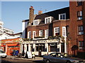
8
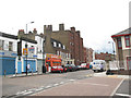
The Hand in Hand, Public House, Streatham Hill
On the junction of New Park Road (in front) and Morrish Road (on the left).
Image: © David Anstiss
Taken: 2 Oct 2011
0.07 miles
9
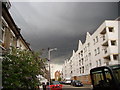
Storm Cloud at Morrish Road, SW2
Looking north-east along Morrish Road towards New Park Road. This storm cloud produced golf ball sized hail over Brixton High Street a few mins earlier.
Image: © Stuart Fisher
Taken: 3 Jul 2007
0.07 miles
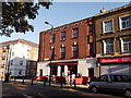
10
New Park Road, Streatham
A typical suburban parade of convenience store, other shops and a pub (the Sultan).
Image: © Stephen Craven
Taken: 20 Aug 2008
0.07 miles