
IMAGES TAKEN NEAR TO
Gaumont Place, LONDON, SW2 4FZ
Introduction
This page details the photographs taken nearby to Gaumont Place, SW2 4FZ by members of the Geograph project.
The Geograph project started in 2005 with the aim of publishing, organising and preserving representative images for every square kilometre of Great Britain, Ireland and the Isle of Man.

There are currently over 7.5m images from over14,400 individuals and you can help contribute to the project by visiting https://www.geograph.org.uk
Image Map
Images are licensed for reuse under creativecommons.org/licenses/by-sa/2.0
Notes
- Clicking on the map will re-center to the selected point.
- The higher the marker number, the further away the image location is from the centre of the postcode.
Image Listing (127 Images Found)
Images are licensed for reuse under creativecommons.org/licenses/by-sa/2.0
Image
Details
Distance
1
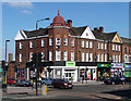
172-178 Streatham Hill
On a prominent position opposite the start of Leigham Court Road. The roofline helps with its semi-hexagonal corner bay topped by a dome with a spire, "ironically not dissimilar to a First World War German soldier's helmet." Ironic because this polite group of shops with flats above was built on the site of Arborfield, a large house destroyed during a Zeppelin raid on 24th September 1916. It is within the Streatham High Road and Streatham Hill Conservation Area.
The course of Streatham High Road has been a major highway between London and Sussex since Roman times. Its current appearance is largely attributable to two major spells of development. The first was during the late C19th following the opening of Streatham Hill station in 1856, and the second was after 1911 when the line to Victoria was electrified. Though much-maligned and undoubtedly blighted by heavy traffic, closer examination reveals that the road is lined with a number of interesting buildings, some of which reflect the period between the wars when Streatham was a fashionable centre of entertainment. Information from Lambeth Council (http://www.lambeth.gov.uk/NR/exeres/CE4B5CE1-0387-40ED-B5A9-273A5160C34A.htm ).
Image: © Stephen Richards
Taken: Unknown
0.02 miles
2
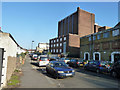
Large building, Blairderry Road, SW2
Boarded up, now demolished and the site redeveloped, along with the nearer building. The high building was at least in part built as the Gaumont Palace cinema, later a bowling alley, with an impressive frontage on Streatham Hill (which survives). The nearer low building is the back of what was built as the Locarno dance hall, later night clubs or similar under various names.
Image: © Robin Webster
Taken: 19 Nov 2011
0.02 miles
3
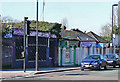
Shops, Sternhold Avenue
This little row of Victorian lock-up shops are round the corner from Streatham Hill station. Three have their original slate roofs (just), and some decorative details have survived too. It is within the Streatham High Road and Streatham Hill Conservation Area.
Information from Lambeth Council (http://www.lambeth.gov.uk/NR/exeres/CE4B5CE1-0387-40ED-B5A9-273A5160C34A.htm ).
Image: © Stephen Richards
Taken: Unknown
0.03 miles
5
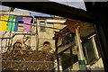
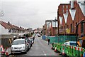
Streatham Hill station works (2008)
During works to renew Streatham Hill station, the roof and rear wall on the northern (Down) platform were removed, revealing the backs of buildings on Sternhold Avenue high above. The multi-coloured building is I think a nightclub – presumably, from the six-colour rainbow, a gay-friendly one. In this view from within a train carriage we can see the staircase from the entrance ending awkwardly where the platform roof no longer meets the staircase covering.
Image: © Christopher Hilton
Taken: 19 Feb 2008
0.03 miles
6
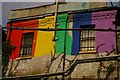
Streatham Hill station works (2008)
During works to renew Streatham Hill station, the roof and rear wall on the northern (Down) platform were removed, revealing the backs of buildings on Sternhold Avenue high above. The multi-coloured building is I think a nightclub – presumably, from the six-colour rainbow, a gay-friendly one.
Image: © Christopher Hilton
Taken: 19 Feb 2008
0.03 miles
7
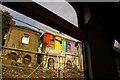
Streatham Hill station works (2008)
During works to renew Streatham Hill station, the roof and rear wall on the northern (Down) platform were removed, revealing the backs of buildings on Sternhold Avenue high above. The multi-coloured building is I think a nightclub – presumably, from the six-colour rainbow, a gay-friendly one. Taken from within a train on the down, southbound platform.
Image: © Christopher Hilton
Taken: 19 Feb 2008
0.03 miles
8
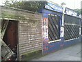
Derelict shop in Sternhold Avenue
It is clearly a good few years since these insurance consultants, next to Streatham Hill station, were giving out advice.
By 2016 the sad remains had been demolished.
Image: © Marathon
Taken: 24 Feb 2011
0.03 miles
10

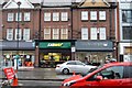
Former Locarno, Streatham Hill
The symmetrical block which includes shops and flats was designed by Trehearne and Norman Preston and Co in a neo-Georgian style. The Locarno ballroom opened in 1929. In later incarnations it was the "Cat's Whiskers", "The Ritz" and "The Studio". It is now "Caesar's", and the dancing therein would probably make the founders of the Locarno blush. It is within the Streatham High Road and Streatham Hill Conservation Area.
The course of Streatham High Road has been a major highway between London and Sussex since Roman times. Its current appearance is largely attributable to two major spells of development. The first was during the late C19th following the opening of Streatham Hill station in 1856, and the second was after 1911 when the line to Victoria was electrified. Though much-maligned and undoubtedly blighted by heavy traffic, closer examination reveals that the road is lined with a number of interesting buildings, some of which reflect the period between the wars when Streatham was a fashionable centre of entertainment. Information from Lambeth Council (http://www.lambeth.gov.uk/NR/exeres/CE4B5CE1-0387-40ED-B5A9-273A5160C34A.htm ).
Image: © Stephen Richards
Taken: Unknown
0.03 miles