IMAGES TAKEN NEAR TO
Thornton Avenue, LONDON, SW2 4BD
Introduction
This page details the photographs taken nearby to Thornton Avenue, SW2 4BD by members of the Geograph project.
The Geograph project started in 2005 with the aim of publishing, organising and preserving representative images for every square kilometre of Great Britain, Ireland and the Isle of Man.

There are currently over 7.5m images from over14,400 individuals and you can help contribute to the project by visiting https://www.geograph.org.uk
Image Map
Images are licensed for reuse under creativecommons.org/licenses/by-sa/2.0
Notes
- Clicking on the map will re-center to the selected point.
- The higher the marker number, the further away the image location is from the centre of the postcode.
Image Listing (103 Images Found)
Images are licensed for reuse under creativecommons.org/licenses/by-sa/2.0
Image
Details
Distance
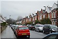
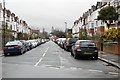
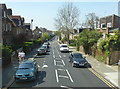
1
Thornton Avenue, B221
The B221 is a way to Stockwell. The bus stop ahead is Criffel Avenue, which is the next left turn.
Image: © Robin Webster
Taken: 19 Apr 2019
0.02 miles
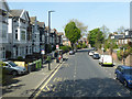
5
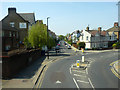
Sternhold Avenue, B221
The B221 turns right here, but Sternhold Avenue goes straight on.
Image: © Robin Webster
Taken: 19 Apr 2019
0.04 miles
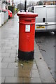
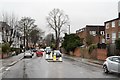
8
Sternhold Avenue, B221
The B221 is a way to Stockwell.
Image: © Robin Webster
Taken: 19 Apr 2019
0.07 miles
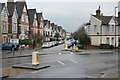
9
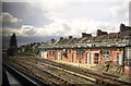
Streatham Hill carriage cleaning sidings, from the train
Image: © Christopher Hilton
Taken: 18 Jun 2011
0.08 miles