IMAGES TAKEN NEAR TO
Hillside Passage, LONDON, SW2 3FE
Introduction
This page details the photographs taken nearby to Hillside Passage, SW2 3FE by members of the Geograph project.
The Geograph project started in 2005 with the aim of publishing, organising and preserving representative images for every square kilometre of Great Britain, Ireland and the Isle of Man.

There are currently over 7.5m images from over14,400 individuals and you can help contribute to the project by visiting https://www.geograph.org.uk
Image Map
Images are licensed for reuse under creativecommons.org/licenses/by-sa/2.0
Notes
- Clicking on the map will re-center to the selected point.
- The higher the marker number, the further away the image location is from the centre of the postcode.
Image Listing (88 Images Found)
Images are licensed for reuse under creativecommons.org/licenses/by-sa/2.0
Image
Details
Distance
1
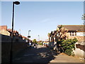
Hillside Passage, Tulse Hill
This path leads from Hillside Road towards Hitherfield Road
Image: © David Anstiss
Taken: 2 Oct 2011
0.00 miles
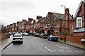
6
Houses in Mount Nod Road
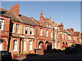
The red tiled houses seen here are typical of the older houses on the ABCD Estate - so called after its principal roads, Amesbury, Barcombe, Cricklade and Downton Avenues. It is more properly known as Leigham Court Estate. The original part of the ABCD Estate was built on the 66 acre estate of Leigham Court which had been purchased by the Artisans, Labourers and General Dwellings Company in 1890. Development took place in the 1890s. This view is from the corner of Mount Nod Road with Hailsham Avenue. With gaps for 'G' 'I' and 'J' the other roads on the estate follow on alphabetically. These are Emsworth Street, Faygate Road, Hailsham Avenue, Keymer Road and Lydhurst Avenue. Only a few similar houses were built in Mount Nod Road, but although logically 'M' is next in the sequence, Mount Nod Road is named after Mount Nod Farm which appears on early 19th century maps.
Image: © Marathon
Taken: 7 May 2014
0.07 miles
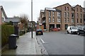
7
Killer cat on patrol
I somehow suspect this cat is not that fierce. Notice seen in Hillside Road.
Image: © Marathon
Taken: 7 May 2014
0.08 miles
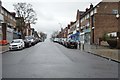
8
Red Brick Houses, Lydhurst Avenue, Tulse Hill
This road has a terrace of red-brick houses (on both sides).
Built presumably, when Image (also in red-brick) was built in 1889.
Image: © David Anstiss
Taken: 2 Oct 2011
0.08 miles
9
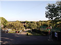
Hillside Gardens, Tulse Hill
This small park and sports fields is on Hillside Road.
In the background the Crystal Palace TV Transmitter can be seen.
Image: © David Anstiss
Taken: 2 Oct 2011
0.09 miles
10
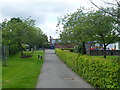
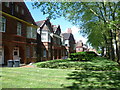
Hillside Gardens Park
Hillside Gardens Park was opened in 1955. This view looks up the central path which leads out to Hillside Road. Tennis courts and a children's playground lie to the left of the path whilst games courts, a One O'Clock Club, picnic and grass areas lie to the right.
Image: © Marathon
Taken: 7 May 2014
0.09 miles