IMAGES TAKEN NEAR TO
Lanercost Road, LONDON, SW2 3DN
Introduction
This page details the photographs taken nearby to Lanercost Road, SW2 3DN by members of the Geograph project.
The Geograph project started in 2005 with the aim of publishing, organising and preserving representative images for every square kilometre of Great Britain, Ireland and the Isle of Man.

There are currently over 7.5m images from over14,400 individuals and you can help contribute to the project by visiting https://www.geograph.org.uk
Image Map (Loading...)


Getting Data...Please wait
Leaflet Map data © OpenStreetMap
Images are licensed for reuse under creativecommons.org/licenses/by-sa/2.0
Notes
- Clicking on the map will re-center to the selected point.
- The higher the marker number, the further away the image location is from the centre of the postcode.
Image Listing (113 Images Found)
Images are licensed for reuse under creativecommons.org/licenses/by-sa/2.0
Image
Details
Distance
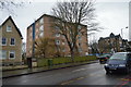
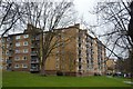
3
Blocks of flats in Tulse Hill
These are part of a very large site managed by St Martin's Community Partnership.
Image: © Bill Boaden
Taken: 1 Feb 2014
0.08 miles
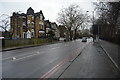

6
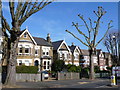
Houses in Palace Road
These Victorian and Edwardian detached houses are in Palace road opposite the junction with Kingsmead Road. The trees have been pruned back to restrict growth.
Image: © Nigel Mykura
Taken: 5 Mar 2013
0.10 miles