IMAGES TAKEN NEAR TO
Fairview Place, LONDON, SW2 2SL
Introduction
This page details the photographs taken nearby to Fairview Place, SW2 2SL by members of the Geograph project.
The Geograph project started in 2005 with the aim of publishing, organising and preserving representative images for every square kilometre of Great Britain, Ireland and the Isle of Man.

There are currently over 7.5m images from over14,400 individuals and you can help contribute to the project by visiting https://www.geograph.org.uk
Image Map
Images are licensed for reuse under creativecommons.org/licenses/by-sa/2.0
Notes
- Clicking on the map will re-center to the selected point.
- The higher the marker number, the further away the image location is from the centre of the postcode.
Image Listing (47 Images Found)
Images are licensed for reuse under creativecommons.org/licenses/by-sa/2.0
Image
Details
Distance
1
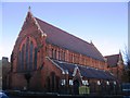
Gospel Tabernacle, Upper Tulse Hill
Built 1894 as St Matthias (Church of England) but since 1981 the Gospel Tabernacle.
Image: © Stephen Craven
Taken: 21 Nov 2006
0.04 miles
2
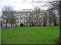
Hyperion House, Upper Tulse Hill
Two linked seven-storey slabs, the second standing behind and parallel. Part of the Roupell Park Estate, built c1960.
Image: © Stephen Richards
Taken: 9 Mar 2020
0.09 miles
3
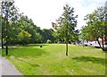
Rush Common
The common is the strip of parkland in the foreground which lies between Brixton Hill Rd and the blocks of flats which are in Redlands Way.
Image: © Nigel Mykura
Taken: 5 Mar 2013
0.10 miles
5
Brixton Hill, Rush Common
A long, narrow strip of open space next to Brixton Hill. http://www.lambeth.gov.uk/Services/Environment/ParksGreenSpaces/Parks/RushCommon.htm
Image: © Mike Faherty
Taken: 18 Aug 2012
0.11 miles
6
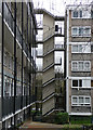
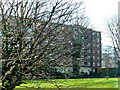
Detail of Hyperion House, Upper Tulse Hill
The sort of eyecatching staircase much indulged in by 1960s architects, often in public housing projects. This links the two blocks (Image]).
Image: © Stephen Richards
Taken: 9 Mar 2020
0.11 miles
7
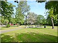
Brixton Hill, Rush Common
A long, narrow strip of open space next to Brixton Hill (to the left). http://www.lambeth.gov.uk/Services/Environment/ParksGreenSpaces/Parks/RushCommon.htm
Image: © Mike Faherty
Taken: 18 Aug 2012
0.12 miles
8
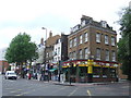
Tuson's Corner, Brixton Hill
Tuson's Corner, a parade of shops at the top end of Brixton Hill in South London.
Image: © Malc McDonald
Taken: 30 May 2011
0.12 miles
10
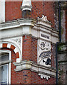
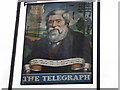
Detail of former pub, Brixton Hill
The name apparently commemorates an experimental telegraph system set up locally in c1815.
Wider view: Image
Image: © Stephen Richards
Taken: 9 Mar 2020
0.14 miles