IMAGES TAKEN NEAR TO
Elm Park, LONDON, SW2 2EE
Introduction
This page details the photographs taken nearby to Elm Park, SW2 2EE by members of the Geograph project.
The Geograph project started in 2005 with the aim of publishing, organising and preserving representative images for every square kilometre of Great Britain, Ireland and the Isle of Man.

There are currently over 7.5m images from over14,400 individuals and you can help contribute to the project by visiting https://www.geograph.org.uk
Image Map (Loading...)


Getting Data...Please wait
Leaflet Map data © OpenStreetMap
Images are licensed for reuse under creativecommons.org/licenses/by-sa/2.0
Notes
- Clicking on the map will re-center to the selected point.
- The higher the marker number, the further away the image location is from the centre of the postcode.
Image Listing (10 Images Found)
Images are licensed for reuse under creativecommons.org/licenses/by-sa/2.0
Image
Details
Distance
1
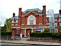
Brixton: Elm Court School
On Elm Park, this is now a fee-paying girls' school.
Image: © Dr Neil Clifton
Taken: 17 Jul 2012
0.08 miles
3
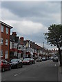
Brixton: Elm Park
Looking south from the end of Leander Road
Image: © Dr Neil Clifton
Taken: 17 Jul 2012
0.16 miles
4
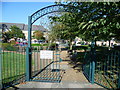
The site of Tulse Hill Comprehensive School
The houses beyond the playground are in Marnfield Crescent. This was originally the site of Tulse Hill Comprehensive, one of the largest schools in London, with over 2,000 boys. It opened in 1956, closed in 1990, and was demolished in the early 1990s. See https://en.wikipedia.org/wiki/Tulse_Hill_School and https://www.gettyimages.co.uk/photos/tulse-hill-school?sort=mostpopular&mediatype=photography&phrase=tulse%20hill%20school
Image: © Marathon
Taken: 28 Sep 2011
0.16 miles
5
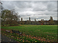
Brockwell Park (1)
Originally the grounds of Brockwell Hall, landscaped by J.B. Papworth, acquired from the Brockwell Estate by the London County Council in 1891, and later extended under the guiding hand of their Superintendent of Parks, Colonel J.J. Sexby, who added ponds, lakes, bandstand and walled garden. The park covers some 120 acres, including the popular lido. The hall now serves as the park's cafe (Image]).
Image: © Stephen Richards
Taken: 17 Nov 2012
0.22 miles
6
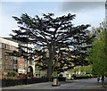
Cedar, Tulse Hill
A sublime Cedar of Lebanon.
Image: © Stephen Richards
Taken: 5 May 2012
0.23 miles
7
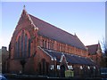
Gospel Tabernacle, Upper Tulse Hill
Built 1894 as St Matthias (Church of England) but since 1981 the Gospel Tabernacle.
Image: © Stephen Craven
Taken: 21 Nov 2006
0.24 miles
8
Brockwell Park (2)
Originally the grounds of Brockwell Hall, landscaped by J.B. Papworth, acquired from the Brockwell Estate by the London County Council in 1891, and later extended under the guiding hand of their Superintendent of Parks, Colonel J.J. Sexby, who added ponds, lakes, bandstand and walled garden. The park covers some 120 acres, including the popular lido. The hall now serves as the park's cafe (Image]).
Image: © Stephen Richards
Taken: 17 Nov 2012
0.24 miles
9
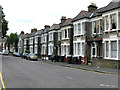
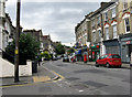
Brixton: Helix Road
Smart and well-kept houses.
Image: © Dr Neil Clifton
Taken: 17 Jul 2012
0.25 miles
10
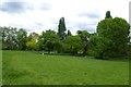
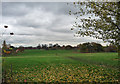
Park near Brockwell Park Row
Looking across a corner of the park near Brockwell Park Row.
Image: © DS Pugh
Taken: 22 May 2016
0.25 miles