IMAGES TAKEN NEAR TO
Tudor Close, Brixton Hill, LONDON, SW2 2AD
Introduction
This page details the photographs taken nearby to Tudor Close, Brixton Hill, SW2 2AD by members of the Geograph project.
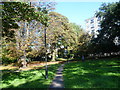
The Geograph project started in 2005 with the aim of publishing, organising and preserving representative images for every square kilometre of Great Britain, Ireland and the Isle of Man.

There are currently over 7.5m images from over14,400 individuals and you can help contribute to the project by visiting https://www.geograph.org.uk
Image Map
Images are licensed for reuse under creativecommons.org/licenses/by-sa/2.0
Notes
- Clicking on the map will re-center to the selected point.
- The higher the marker number, the further away the image location is from the centre of the postcode.
Image Listing (62 Images Found)
Images are licensed for reuse under creativecommons.org/licenses/by-sa/2.0
Image
Details
Distance
1
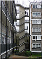
Detail of Hyperion House, Upper Tulse Hill
The sort of eyecatching staircase much indulged in by 1960s architects, often in public housing projects. This links the two blocks (Image]).
Image: © Stephen Richards
Taken: 9 Mar 2020
0.06 miles
2
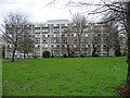
Hyperion House, Upper Tulse Hill
Two linked seven-storey slabs, the second standing behind and parallel. Part of the Roupell Park Estate, built c1960.
Image: © Stephen Richards
Taken: 9 Mar 2020
0.08 miles
3
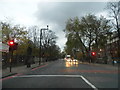
Brixton Hill
The entrance to the prison is in the turning on the right of these lights, Jebb Avenue
Image: © David Howard
Taken: 24 Nov 2013
0.09 miles
4
Brixton Hill, Rush Common
A long, narrow strip of open space next to Brixton Hill (to the left). http://www.lambeth.gov.uk/Services/Environment/ParksGreenSpaces/Parks/RushCommon.htm
Image: © Mike Faherty
Taken: 18 Aug 2012
0.09 miles
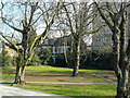
5
Rush Common, Brixton Hill
There is a near continuous linear park along the east side of Brixton Hill. Known as Rush Common, this section is between Endymion Road and Beechdale Road. Along this stretch of Brixton Hill, set well back, were Raleigh Hall and Raleigh House. They have been long since demolished but their gardens and a field which fronted Brixton Hill form part of Rush Common.
Image: © Marathon
Taken: 28 Sep 2011
0.10 miles
6
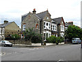
Brixton: House on Beechdale Road
Showing that not all property in Brixton is run-down or dilapidated.
Image: © Dr Neil Clifton
Taken: 17 Jul 2012
0.10 miles
7
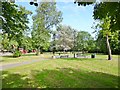
Small Park
This small patch of park is on the Brixton Hill road between Endymion Rd and Beechdale Rd.
Image: © Nigel Mykura
Taken: 5 Mar 2013
0.11 miles
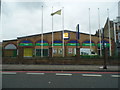
9
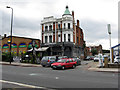
Brixton: The Music Bar
On the west side of Brixton Hill, this is the former George I public house. In the background is seen part of Brixton Prison.
Image: © Dr Neil Clifton
Taken: 17 Jul 2012
0.11 miles
10
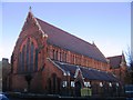
Gospel Tabernacle, Upper Tulse Hill
Built 1894 as St Matthias (Church of England) but since 1981 the Gospel Tabernacle.
Image: © Stephen Craven
Taken: 21 Nov 2006
0.11 miles