IMAGES TAKEN NEAR TO
Saltoun Road, LONDON, SW2 1ER
Introduction
This page details the photographs taken nearby to Saltoun Road, SW2 1ER by members of the Geograph project.
The Geograph project started in 2005 with the aim of publishing, organising and preserving representative images for every square kilometre of Great Britain, Ireland and the Isle of Man.

There are currently over 7.5m images from over14,400 individuals and you can help contribute to the project by visiting https://www.geograph.org.uk
Image Map
Images are licensed for reuse under creativecommons.org/licenses/by-sa/2.0
Notes
- Clicking on the map will re-center to the selected point.
- The higher the marker number, the further away the image location is from the centre of the postcode.
Image Listing (342 Images Found)
Images are licensed for reuse under creativecommons.org/licenses/by-sa/2.0
Image
Details
Distance
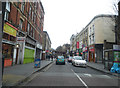
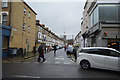
1
Kellett Road
Looking along Kellett Road from the junction with Talma Road.
Image: © DS Pugh
Taken: 22 May 2016
0.03 miles
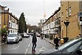
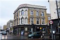
6
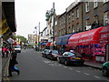
Atlantic Road SW9
Looking towards Coldharbour Lane. Brixton Station is above, the platforms slightly overhanging. Incidentally, the OS 1:25000 on Get a Map shows it as Clapham Junction Station, and shows the Underground station some 300 metres to the NE of where the entrance actually is.
Image: © Danny P Robinson
Taken: 9 May 2006
0.07 miles
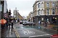
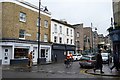
7
Mervan Road, SW2 (2)
Shows the location of Image
Image: © Mike Quinn
Taken: 12 Jun 2008
0.07 miles